Showing posts with label France. Show all posts

2019-01-05

All the Isidorian Bibles Online

A very special set of medieval bibles is complete at last, thanks to the recent digitization of the Foigny Bible in the French National Library, some of the best news of last year for codicologists.

These rare Vulgate bibles, one from Burgos in Spain and three from the Meuse Valley on the Franco-Belgian border, offer the sole surviving evidence of a shadowy struggle over belief in seventh-century Visigothic Spain.

Four years ago, I celebrated the arrival online of the Floreffe Bible (now in the British Library). Now the fourth and last is there to appreciate, the Foigny Bible, thanks to the Polonsky Foundation funding a project to virtually unite treasures of London and Paris that belong together. The illuminations in the Foigny Bible (here the Nativity) are wonderful:


Here are links to the whole set of four:

The Foigny Bible starts off with a prologue set which is found in the others too, a fairly sure sign that all these 11th and 12th century bibles derive from a much earlier model:
  • an arbor consanguinatis;
  • the Great Stemma, with a 6,000-word epitome of exegesis by Isidore in the blank spaces;
  • the Prologus Theodulfi
  • a second Prologus (Stegmüller, Rep. Biblicum, n° 284).
  • a second Prologus (Stegmüller, Rep. Biblicum, n° 285).
  • a capitula
And what were the Visigothic Christians arguing about? Whether St. Joachim, the supposed grandfather of Jesus existed! 


A late-antique "family tree" of Jesus, the Great Stemma (above), had been spreading through Iberia in the seventh century and it showed a legendary sheep-farmer, Joachim, in pride of place. Isidore of Seville thought this claim was nonsense. We don't know if Isidore himself altered the chart, but someone very smart and aligned with Isidore's thought took pen and rewired the "tree", cutting out poor Jo like a gastric bypass.

As for the 6,000 words of Isidorian Exegesis written in the gaps, you'll  have to make up your own mind who wrote it. Maybe that was Isidore too? Since it had never been identified or published previously, I edited the text some years ago.

2018-04-18

A New Look at the Albi Mappamundi

The two most ancient map-style manuscripts in existence are the Albi Mappamundi and the Vatican Mappamundi. Both of these western charts of the Mediterranean-centred world were made in the second half of the eighth century, let's say about 770. One or other may turn out a decade or two older, but until someone scientifically dates the sheepskin on which they are drawn, we have to treat them as equally old.

I have just digitally plotted the Albi Mappamundi with a view to adding it to my Library of Latin Diagrams:

The inspiration for this burst of activity was the appearance online of a very comprehensive, very up-to-date article about the Albi Mappamundi by Anca Dan. La mappemonde d'Albi - un pinax chôrographikos was published in December and she has just been kind enough to post a scan of the article on her Academia.edu page.

She traces this early medieval mappamundi back to a model by Eucher of Lyon, a late-antique Christian leader, based in turn on similar diagrams from his own schooling.

The article's title subtly reminds us that the word mappamundi would have drawn blank looks in antiquity. The term did not exist then. If you had however said pinax chôrographikos (based on a couple of Greek-origin words) to Eucher, he would have got your drift. 

Schools in classical and late antiquity did not teach geography (too mathematical and of no practical use) but chorography (the size, accessiblity, appearance and hospitableness of places, who lived in them, what they produced). So this is a chorographic pinax (chart). Because of that human-practical focus, a mappamundi never shows the absolute positions of places like a true map, but rather their relative positions: what you have to pass by or cross to arrive at a further place.

Readers will recall that I wrote a blog post in 2016 about the arrival online of the Vatican Mappamundi, which is bound (fol. 63v-64r) in codex Vat.lat.6018. The Albi Mappamundi has been online since its Unesco recognition in 2014. Unfortunately I cannot link you directly to fol. 57v-58r of the codex which contains it. Go to the opening page of that codex, ms Albi 29, and page through to image 115.

Dan, Anca. ‘La mappemonde d’Albi - un pinax chôrographikos. Notes sur les origines antiques de la carte et du texte du ms Albi 29 fol. 57v-58r’. Cartes & Géomatique. Revue du Comité français de cartographie, no. 234 (December 2017). Online.

2018-02-03

Backbone of Europe

The oldest chart of the western world, the Tabula Peutingeriana, would be better known to map enthusiasts if it were an approachable document. But on a first look, the scroll, which was designed in the Roman Empire, seems pretty incomprehensible. Of course it's in Latin, but that's not even the biggest problem. The chart is not to scale, but uses a strange squashed "projection", and it's infernally hard to guess where any of its roads go.

Help is at hand at last with my new chart of northern France, Germany, northern Italy, Austria and Slovenia which picks out what you need to know about the part of the Tabula covering Europe's most prosperous areas today.
What is striking is that the ductus of the Tabula -- and an awareness of the geography on the ground -- points to our designer having chosen a main road leading all the way from Boulogne, France to Rimini, Italy as his centerpiece.

This backbone, colored wine-red in my analytical diagram, passes through Reims, Besançon, Lausanne, the Great St Bernard Pass and Cesena. It's not the same as the medieval Via Francigena which led from Canterbury via Florence to Rome, but both the high roads served the same traffic and had many stretches in common.

Another big takeaway: the Tabula Peutingeriana is not oriented north-south. "Up" is north-west. Use the interactive control "Landmass" to see the coasts which the late antique designer had in mind. Of course the match is not perfect: Boulogne ends up on top of London, Leiden in the North Sea and Milan perched on the bank of the Rhine. But it's remarkable that anything matches in something that initially appears so chaotic.

What we are seeing is a very different take on Europe from that we are familiar with in modern maps. This is Roman Europe, with a fortified border in the north along the valleys of the Rhine and Danube (the dark blue line at top). It's also a Europe where most long-distance travel is obstructed by the Alps. The interactive control "Passes" shows how these seal off northern Italy. You can't go round them (except by ship): you have to over them as the playground song tells us.

To prove I haven't cheated, use the interactive control "Manuscript Sections" to see how the places form columns. The vertical layout precisely matches that in the Tabula, a UNESCO Memory of the World treasure now kept in a vault in Vienna. Tell me if you spot any errors. And if you want to see a similar chart of southern Europe, check out my previous blog post, Two Frances.

2017-12-20

Two Frances

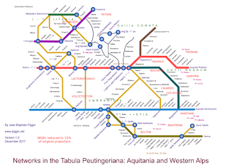
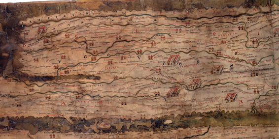
My analysis of the Tabula Peutingeriana's western end has yielded a big surprise. To see what this is about, take a glance at how the manuscript depicts the area we associate with modern France (below):

It's strangely formless. Definitely not a hexagon. The Atlantic coast at left seems to have gone mostly missing. The outline looks vaguely like a sperm whale. What's that strange mouth or slit in the left-hand edge? Scholars have always been astonished at the crudeness of this late-antique "map". So I wasn't expecting to find any graphic intricacy here.

But there is something clever going on, and the first clue is that slit, which is marked Sinus Aquitanicus, the Bay of Aquitaine or as would today say, of Biscay. All seas and gulfs in the Tabula Peutingeriana (TP) are compressed into river shapes, so it is in itself unremarkable that the Bay of Biscay is not being shown here as the wide bight we are familiar with from modern maps.

The area below the slit was evidently marked Aquitania in the original TP, though some letters are now missing.

What is peculiar is the way the slit separates places which we would conventionally expect to abut one another on the plains of western France. At the deepest point of the slit is the inland city of Lemuno (Poitiers), on its top flank are Dartoritum (Vannes) and Portu Namnetum (Nantes)  and on its bottom flank are Audonnaco (Aulnay) and Mediolano Sancorum (Saintes), all inland.

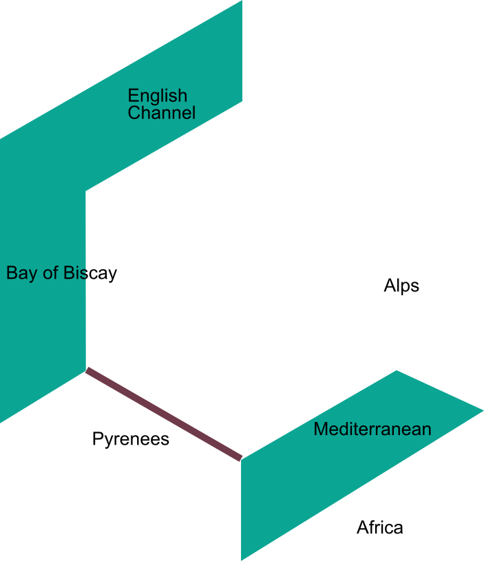
To grasp how this odd watery border has arisen, the best tool of thought is the hexagon, a meme which normally denotes the political frontiers of modern France, but which I will apply to the natural limits, mountainous and marine, of Roman-era Aquitania and transmontane Gaul as far as the left bank of the Rhine:

My method for analysing pre-medieval charts is based on the observation that there are graphic continuities and discontinuities in every large diagram. These become obscured during cumulative copying by scribes. The TP's principal continuities are its long-distance routes, probably based on recorded itineraries. As a matter of prudence, I now denote these as "courses", since it cannot be proven that the TP itself was ever intended to guide travel.

In the present state of the TP - preserved as it is in a single manuscript from late in the long 12th century - some of these courses have become obscured by crowding, but can be recovered by careful examination. Where a long horizontal series of chicanes - the vernacular of the diagram - matches a direct-line, real-world journeying route, we are likely to have found such a course.

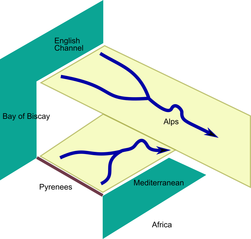
As far as I know, scholars have previously failed to notice that in Aquitania, correspond to roads running from southwest to northeast into the Alps, whereas in Gaul and the rest of the West, the TP privileges a set of courses that align with roads running northwest-southeast. Below, I have added a couple of pale yellow parallelograms to the hexagon to show these contrary orientations:

These continuities lead us in turn to discern a discontinuity. There is a break between these two sets of courses. Part of that break is formed by the Sinus Aquitanicus slit, and the rest of the break spreads to the right: a zone of transition where the courses of the two types are tangled or contorted or there are unaccountable blanks. I will develop these observations in detail further on.

The most plausible explanation for such a discontinuity would be that the TP was constructed from two separate data-sets, or perhaps even from two pre-existing charts. I have recently analysed the southernmost of these two datasets, the region abutting the Pyrenees and the Mediterranean, and established that it emphasizes seven main routes which vary in length, are more or less parallel and are connected to one another by shorter minor routes. The following transport-system diagram is the result of this analysis:

You can see here two main horizontal courses (red and blue) flanked by the dark green, purple, chocolate, chartreuse and olive green courses (five in all) that are semi-parallel to them. The 15 yellow courses are transverse connections. It is surprising that a journey which modern travellers would regard as a trunk route, the Rhone valley highway from Arles to Valence to Vienne, is treated here as a minor link. The six thin curved lines represent connections near Lyon that do not fit this context. That is because they belong to the transition zone.

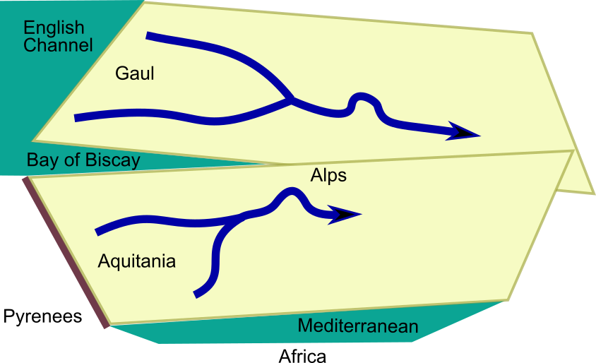
I have not yet completed a similar analysis for northern Gaul, but can say already that that part of the TP emphasizes a set of courses running from Normandy and the English Channel across to the main Alpine crossings..

Armed with this knowledge, we can estimate with greater confidence how the TP was put together. To merge the two datasets, the sub-maps had to be rotated so that all the courses were depicted more or less in parallel. The Bay of Biscay was changed from a full side of the hexagon to a mere slit between the two sections, and the Mediterranean Sea was squeezed down to a kind of river:

Let's finish with a look at the zone of transition, depicted in my abstract above by thin black curving lines. The labels are more legible in my plot than in the manuscript, so let's use that for the discussion.

The road southwards from Cabillione (Chalon) to Lugduno (Lyon) is depicted as a vertical ladder, a rather exceptional graphic form for this chart. Augustodunum (Autun) which is at a more northerly latitude than Chalon is nevertheless shown directly below it. The principal paved Roman crossing of the Morvan uplands is that from Autun to Autessioduro (Auxerre), whereas the connections from Autun to 
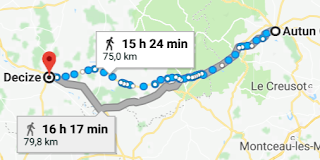
Degetia (Decize) - just peeping above from the left margin - are of less importance.

Here there appear to be no fewer than three courses: via Aquae Nisincii (Saint-Honoré-les-Bains?); via Boxum (Bussière?); and via Aquae Bormonis (Bourbon-Lancy). (For an up-to-date discussion of these identifications and their past as sacred Celtic sites, see Nouvel (2012) and Hofeneder (2011).)

If we consult this 75-kilometre-wide space on an online map, it's noticeable that these three courses relate to a tiny geographical area, with a radius of a single day's walk. Yet the area is being given unusually detailed treatment in the TP. Its paths are circuitous, poorly aligned with the major east-west courses to the north and south and too local for long-distance travel. The chart's graphic arrangement of the small towns and spas does not even represent their real-world spatial organization very well.

I have suggested in the case of Italy that such passages in the TP are most likely to be write-ins on the chart where general consistency was no longer achievable and insufficient blank space was available to make the additions coherent. It is for this reason that I exclude them for the time being from the main analysis and treat them as if they were glosses.

My working hypothesis is that not all lines on the TP are alike: some are primary courses, offering chains of straight-line distances that stretch across regions, others are secondary or local courses, showing cross-connections between the primary courses, and others again are infillings or graphic annotations added after the chart was completed.

The zone between Decize, Chalon and Lyon may have been left blank in the earliest version of the TP, extending inland the watery blank formed by the TP's Sinus Aquitanicus

Hofeneder, Andreas. ‘Tabula Peutingeriana’. In Die Religion der Kelten in den antiken literarischen Zeugnissen 3, Vol. 75. Mitteilungen der Prähistorischen Kommission. Verlag der Österreichischen Akademie der Wissenschaften, 2011.

Nouvel, Pierre. ‘Les voies romaines en Bourgogne antique: le cas de la voie dite de l’Océan attribuée à Agrippa’. In Voies de communications des temps gallo-romains au XXème siècle, edited by C Corbin, 9–57. Saulieu, France, 2012.

2014-11-02

Floreffe Bible now Online

The only way that we know that a graphic artist – or studio – in the fifth century CE drew a magnificent chart of biblical history and genealogy is from the later copying of that work onto parchment manuscripts during the medieval period. Fortunately, 24 such copies are still in existence.

Since I began studying the Great Stemma in 2009, there have been constant advances by museums, archives and libraries in bringing digital versions of this chart online. The British Library has now added the Bible of Floreffe Abbey to its collection of over 1,000 online manuscript digitizations. This must have happened rather quietly, as I have not seen it mentioned in the BL blog yet.

For the study of the Great Stemma, this is a rather important development. Until now, just seven of the manuscripts had been issued online, but nowhere on the internet could one study a peculiar evolution of the Great Stemma into what I call the "School Stemma," a revision of the graphic to bring it in line with orthodox, 12th-century doctrine about the ancestry of Christ.

The Floreffe Bible contains a beautifully coloured version of the School Stemma, with exquisite script that faithfully reproduces all the defects and nonsenses of whatever text it was modelled on. Check it out and page through its glories.

We do not yet know where the revision took place. I call it the School Stemma because I guess that it was "cleaned up" so it could be safely taught to impressionable young monks. Charts containing this version also come from Parc (now Belgium), Foigny in France and Burgos in Spain. The chart may also have been copied at Arnstein, Germany as well.

As a result, I have revised my table of Great Stemma manuscripts, doing a good deal of re-arranging to make the layout more user friendly. It will be clear after consulting the table that not only are eight of the 24 manuscripts now available online and readable in their entirety, but that these neatly cover six of the seven recensions (alpha, beta, delta, gamma, epsilon and School). Additionally, the sigma recension is online at the BNF, though the resolution there is too low for a visitor to read the script.

As a result, the Great Stemma can now be seen on the internet in its complete range of forms. By the greatest of good luck, the four manuscripts which offer the best evidence about the fifth-century ur-form (Plutei, Roda, San Millàn and one of the School group) are now all accessible. One could hardly wish for more.

My table tabulates all these online witnesses. The amber-gold squares in the table mark all the high-resolution images where you can click through to each archive's website. The paler yellow squares mark low-resolution images and snippets.

Happy clicking.

2013-11-05

Transcript in France

A transcription of the Great Stemma text from the Saint-Sever Beatus has appeared in France, along with a detailed introduction to the entire manuscript. There is no date on the transcription, but the file was last modified 2013 February 4, so I presume it was completed last winter. My own five-manuscript transcription does not include Saint-Sever, so scholars will now have six texts they can compare.

This appears to be only the second time, after my own publication of 2010, that the entire text of the diagram has been published. The authors of this welcome new work appear to be Jean Cabanot, who has a long association with studies of this codex, and Georges Pon. The complete history of the text's publication with editors in brackets would thus appear to be as follows:
  • 1951 transcription of the Genesis text from four bibles only (Bonifatius Fischer)
  • 2010 complete transcription on Piggin.net (Jean-Baptiste Piggin)
  • 2013 Saint-Sever transcription (Jean Cabanot and Georges Pon)
There is also an 80-page Introduction générale to the manuscript, apparently by the same authors. I have yet to read this, but from a digital search I note that it does not appear to mention the new edition of the Beatus Commentary by Roger Gryson. The website belongs to the Comité d’études pour l’Histoire et l’Art de la Gascogne.

Regrettably, there are no high-resolution scans of the manuscript itself. Some low-resolution scans are linked to from my website.

2013-09-04

Cassiodorus Digital

Since I first published several years ago a hyperlinked listing of the 37 diagrams "made up" by Cassiodorus for his Institutiones, two key sources have become available digitally: the great 8th-century codex from Monte Cassino now at Bamberg, Msc. Patr. 61, which contains the complete set, probably in the final form approved by Cassiodorus for publication, and Mazarine 660, which contains some peculiar variations in the motifs used in the diagrams. The tabulated listing now includes links to all these images, making it an excellent tool for comparing their evolution in the first millennium. The drawings from Mazarine 660 are to be found on the Liber Floridus illuminations site.

It is remarkable how much has changed in the 13 years since the definitive article on the Cassiodorus diagrams by Michael Gorman was published and included this comment:
Today it is relatively cheap and easy to buy a microfilm of a manuscript and print it out on paper, but in the 1930s this was a luxury that could probably not even be imagined ... I hope this note is sufficient to stimulate interest in preparing a facsimile of the Bamberg manuscript ... (pages 39, 41)
Since that was written, another unimaginable barrier has been breached and it has become possible for anyone to see these manuscripts at no charge via the internet, making facsimiles less necessary.

This update is one of three data upgrades to the Macro-Typography website that have been accomplished in the past month. The collation of the Great Stemma now contains a properly checked fifth and last set of text variations, from the Gamma manuscripts. This was previously bodged together from Fischer's Genesis edition and my transcription of the Urgell Beatus. The Gamma text is now based on a sounder manuscript, that in the San Juan Bible, with the Urgell Beatus only required to fill gaps. This data entry was a lot of work at an unwelcome time, but means that I can now close off the transcription phase with a good conscience.

The third of the upgrades has been some supplementing of the Petrus Pictaviensis table on my website. The major new find there has been a digitization (by Heidelberg) of one of the manuscripts in the Vatican Library. I have also restored the Walters digitization which for some inexplicable reason I had deleted from the list. This means there is an even wider range of quality digitizations -- 22 -- of the Compendium available for comparison.

In addition to these, I continue to keep an eye out for any more additions to the Stemma of Boethius tabulation I completed in the late spring.

Gorman, Michael. “The Diagrams in the Oldest Manuscript of Cassiodor’s Institutiones.” Revue Bénédictine no. 110 (2000): 27–41.

2012-07-19

Finding Bernhard Pez

Bound into Heinrich Brauer's papers on the Compendium of Peter of Poitiers (the subject of my preceding blog post) is a library research report dated 1951 May 9 compiling reference-book data on this 12th-century work. It was drawn up by the Staatsbibliothek (then the Öffentliche Wissenschaftliche Bibliothek in the Soviet-controlled sector of Berlin).

It is evidence of the industrious help that could once be obtained from research library staff, back in the days before the budgets of such institutions were cut. Brauer was living and working in Celle, half a day's train ride from Berlin, but was able to save himself the trip to Berlin by simply writing and asking for an "Auskunft". We are immeasurably better off nowadays with the instant access available via the internet.

The reply from Berlin is of no great scholarly value and is defective in not containing any mention of the principal survey of Peter's work then in print, that published by Moore in 1930. The librarian also promises to inquire at other German libraries, but as there is no letter on file with any such results, this probably led nowhere. However one of its references, to Bernhard Pez, caught my eye.

The compilation duly mentions the editio princeps by Zwingli the younger published in 1592 in Basle and quotes from a series of reference works:
  • Georgi: Allgemeines europäisches Bücherlexikon
  • Jocher: Allgeneines Gelehrten-Lexikon
  • Nomenclator literarius theologiae catholicae
  • Wetzer und Welte: Kirchenlexikon
  • The Catholic Encyclopedia
  • Histoire littéraire de la France, vol 16
The last of these can be consulted on Google Books and the librarian quotes its mention of an edition by Pez based on the manuscript from "Metsen" in the diocese of Passau, Bavaria. This is a misprint or authorial error for the Benedictine house Kloster Metten.

Bernhard Pez was the librarian of the Benedictine abbey of Melk in Austria and volume 1 (published in 1721) of his Thesaurus anecdotorum novissimus notes that he found a copy of the Compendium in the monastic library during a visit to Metten. The Thesaurus has been digitized by the MDZ (click on the link and go to page 59 of the scan). A researcher has usefully added the handwritten information that the Compendium is at folio 101 of the codex, and Pez states:
Petri Pictaviensis Compendium historie veteris ac novi Testamenti, quod incipit: considerans historiae sacrae prolixitatem etc.
One presumes this manuscript is now in the state library in Munich.

2012-02-18

Peter's Compendium

So far this blog has not directed much attention to the Compendium historiae in genealogia Christi, a 12th-century work by Peter of Poitiers which presents a completely new stemmatic diagram. Peter was a believer in the Trinubium, the three marriages of St Anne, and his vast genealogical infographic went into wide circulation in medieval Europe. There is no evidence the Compendium is adapted from the Great Stemma, though it seems plausible that Peter would have known of the Great Stemma and would have been inspired by it to design his own diagram ab initio.

In his 1943 article in Estudios Biblicos on the Great Stemma, Teófilo Ayuso claims that one of the codices where it is reproduced is a 14th- or 15th-century bible at the University of Barcelona, which his 1943 article terms Barc1, though it later becomes Barc3 in his peculiar numbering. This is online: I found a digital version yesterday. Its call number is Sig. Ms. 762. (There is another fine Barcelona University bible online, Sig. Ms. 856, but this does not contain any stemmata.) Sig. Ms. 762 is described at volume 2, page 308 of Miquel Rosell's printed catalog as follows: Ff. 2-7. Genealogias. Inc.: De Cain. Cain agricola dolens ... Expl.: De Tiberio ..., sub quo Dominus est passus. It also contains an Interpretationes Hebraicorum Nominum.

It is clear from only superficial examination that including this bible in the Great Stemma camp is another of Ayuso's blunders. The Barcelona bible very clearly contains the Compendium diagram, not the Great Stemma.

This can be readily seen by comparing it to other codices. There are several good online presentations of the Compendium. An impressive one is Ms Typ 216 at the Houghton Library of Harvard University, a roll-manuscript (probably intended for use as a wall-chart). It can be viewed in sections here.

There is a finely drawn 12th-century (?) version in codex form in the Biblioteca Medicea Laurenziana in Florence, spread over 10 pages in an anonymous seven-folio document, Plut.20.56 (5v is the final page of the diagram). An early 13th-century manuscript from England now in Paris, Lat. 15254, contains the same chart. I expect there are many others, but this is what some searching today turned up. [An excellent starting point is Nathaniel Taylor's survey, and I see the Met Museum also has a damaged scroll which is online in low resolution.]

As far as I know, there has been no printed version since the rather inaccurate editio princeps of the Compendium published by Zwingli in 1592, which differs in signal ways from the manuscripts above. MDZ offers it digitized. I have not done a bibliography on the Compendium yet, but it is discussed at length by Christiane Klapisch-Zuber in chapter 6 of L'Ombre des Ancêtres and there are some articles mentioned in a footnote by Stork.