Showing posts with label Italy. Show all posts

2019-04-23

Holy Mountain

One of the many curious features of the Tabula Peutingeriana is a depiction of Monte Tifata, a holy mountain in Campania, Italy. Tifata is a strong point, a ridge 600 metres high with steep slopes. From the top you get a view both ways along the Via Appia, and also to Vesuvius to the south and the River Volturno below (Corryx, Wikipedia, 2016).

The Tabula depicts Tifata Mons with two notable temples and a sacred spring:
From left to right (west to east) these places are the Baths of Sulla, a Temple of Diana (Diana Tifatina) and a Temple of Jove (Iovis Tifatinus). The whole drawing seems to be fairly accurate, as it is now accepted that the temple to Diana was at the western foot of the mountain and its stone is probably incorporated within the walls of the splendid Benedictine basilica of Sant'Angelo in Formis. Note how the temple at right seems to be drawn in a perspective suggesting it is on a height.

Stefania Quilici Gigli hypothesizes that the Baths of Sulla were close by. Lucius Cornelius Sulla Felix (c. 138 BC – 78 BC) had won a victory at Caio Norbano near here on his 83 BC March on Rome. The Roman historian Velleius states that Sulla made a foundation of land and waters here to celebrate this, reading thus in the Shipley translation
It was while Sulla was ascending Mount Tifata that he had encountered Gaius Norbanus. After his victory over him he paid a vow of gratitude to Diana, to whom that region is sacred, and consecrated to the goddess the waters renowned for their salubrity and water to heal, as well as all the lands in the vicinity. The record of this pleasing act of piety is witnessed to this day by an inscription on the door of the temple, and a bronze tablet within the edifice. 
This does not explicitly say there were baths, but Stefania Quilici Gigli thinks nearby land-marker inscriptions of a later period refer to this land use and both custom and the Tabula would indicate the “waters” were utilized as baths. The purpose of bathing would have been healing rather than play.

The temple of Jove is thought to have been at the summit, near today’s illuminated cross, the Croce del Tifata:


A hiking trail to this is shown on an Italian trails site, Sentieri dei Colli Tifatini.

Knowing all this, the illustrations in the Tabula are most interesting. The two pictures of temples are of a type, but with different fronts. One (Diana) shows a rose window in the front, the other (Jove) shows a high doorway, and I realize after seeing a picture of Sant'Angelo that this probably represents an arch added at the front:

The third image shows an expansive building of two storeys with a tower and a similar arched entrance at left. The usual Tabula icon for a baths lacks such a tower, so perhaps the extra element is a distinctive feature of the Tifata site.

As I note above, I am sceptical of the view (forever associated with the Levis) that baths on the Tabula denote places of recreation. I suggest the primary connotation of such buildings for pre-Christian readers was as ritual sites, and thus the focus would be on the magic rather than the purely pleasurable quality of the waters.

2018-05-24

Via Appia Found on Satellite Image

The Appian Way is perhaps the world's most celebrated road. On the outskirts of Rome it is a major tourist attraction. I have just discovered you can see some of its far reaches on photographs from space.

The Way seems to be the source of a common misconception in the English-speaking world that all Roman roads were solidly paved and ran straight as a laser, up hill and down dale, never yielding to the lie of the land. Beyond Terracina, much of the Via Appia was neither paved nor straight, but wriggled along long-worn prehistoric ridgeway routes, where the ground was drier (and harder) and the traveler had the best chance of spotting approaching attackers, whether they were bandits or bears.

Begun under the direction of Appius Claudius, a consul, in 312 BCE, the Via Appia initially connected Rome to Capua near Naples. Later it was extended to Brindisi on the Adriatic Coast. It was any physical traces of this latter extension that I was hoping to find while on a visit last week to Italy.

We were staying in the newly elegant city of Matera which is dolling itself up to be one of two European Capitals of Culture of 2019. In Roman times, Matera was just a remote warren of hand-hewn caves, never mentioned in the ancient sources. Perhaps it was a refuge of the above-mentioned bandits, who could murder a merchant on the Via Appia at dusk and carry the booty 15 kilometers away to the caves to hide it, safely holed up by midnight like the Ahlbergs' brigands:

Near Matera one finds two modern highways named Via Appia. The one beginning from Ferandina, national highway SS7, and proceeding via Matera to Massafra is a fake, although it too terminates at Brindisi. The other, Puglia provincial road SP28, marked "Strada Provinciale Appia" on maps, is, in some stretches at least, the real thing.

Recent articles by Luciano Piepoli dispense with the armchair scholarship (mainly German) about this part of the Via. They assemble new hard archaeological evidence about its course and stage-stops. Unfortunately Piepoli does not provide GIS geolocations (this ought to be prescribed by the style guides of every journal dealing with historical geography). He writes:
The Appian Way, at the exit from the current town of Gravina in Puglia, begins its path in a south-easterly direction near Scomunicata and, after having touched the localities of Graviscella and Ponte Padule Cardena, reaches the rocky outcrop of the Murgia Catena, located about 7 km southeast of Altamura. The road runs along the southern slope of this last location to Iesce, where there are the remains of an important settlement that had been abandoned by the 2nd century B.C. On the territory of Altamura, in a flat section between the southern slope of the Murgia Catena and the hillock of Montepovero, the projecting traces of wheel ruts are visible in the rocky surface for a length of about 200m and a total width of more than 30m, forming multiple lanes. Although they are not contemporary with one another, it appears highly probable by virtue of their topographical location that some of them must derive from the consular Via Appia. (My English, helped by Apple and Google Translate).
Hoping to see these traces of the wheels of ancient or medieval carts, we stopped our car on the shoulder of the SP28 at what we thought was the spot. Since a narrow lane of wheat was growing there on the verge of the road itself, we searched the rocky field behind it, but to no avail. On the point of giving up, and after nearly stepping on a sturdy snake, I finally discovered the ruts further up the road.

In the 50-second video above you may hear a cicada and will see the colorful wild flowers of a southern Italian spring including tall fennel, all growing in the dirt that has collected in the ruts.

The most pronounced track is at the left, close to the dry-stone wall. There are no doubt specialists who could estimate from the wheelbase whether this track is ancient or medieval. A second, shorter bunch of tracks can be found about 50m further down the hill (in a 24-second video). I have uploaded videos of both to my YouTube Channel.

The greatest surprise came later: these ruts are visible on common garden satellite imagery. When I studied the same location on Google Maps later, I was amazed to see the big set of ruts quite clearly at the location 40.76424, 16.61516 (tip: copy just this to any sat-nav or mapping app to find it):

As far as I know, this remarkable, aerially visible archaeological site is not listed on any of the ancient geographical portals such as the Digital Atlas of the Roman Empire, Pelagios or Vici. I can see how to add it to Vici (and will add it later), but I must admit that I have no idea yet how to contribute it to the former two. They do not offer any "guide for dummies" instructions.

These stone remains are no longer 30 meters wide, since the new road passes through the middle, and they do not seem to have gained any legal protection, although the feature is surely known locally. The IGM map of 1919 (reproduced as British AMS M791 of 1939) labels a nearby stretch of the road "od via antica Via Appia" (I don't know what "od" means).

Piepoli relies on a survey of the area by the great aerial archaeologist of the 1920s to the 1950s, Giuseppe Lugli, so I presume these remains are mentioned in Lugli's books or articles. As far as I can tell, they are the only surface evidence left of the ancient Via Appia between Gravina and Tarento.

The fact that wheels ran across bedrock here is an indication that the highway was unpaved. A few kilometers away, the route has been archaeologically excavated. Piepoli writes:
Near Masseria Capitolicchio Vecchia, recent excavations conducted by the Archaeological Superintendency of Puglia have highlighted a short stretch (about 200 x 4.90 m) of a road - of the glareata type - interpreted, on the basis of the construction technique, orientation and topographic context, as a segment of the Appian Way [Mattioli, 2002]. An interesting fact which emerged during the excavations is that the roadway is partially obliterated by a layer of relative collapse likely due to a structure located near the road axis. The ceramic finds and coins found can be dated between the end of the 2nd century BC and the 3rd century AD, which could be considered as a terminus post quem for the abandonment of the Via Appia in this section.
The simple glareata road had a base of stones, built up to a sand or gravel surface, and would be kicked or ground apart by heavy traffic if it were not maintained. This is probably what happened at 40.76424, 16.61516, exposing the bedrock to the grinding of cart and carriage wheels. Above, I mentioned a narrow crop of wheat growing in the queen's acre (the roadside). It too is clearly visible in the space imagery, and occupies what seems to have once been a ford through a seasonal stream, the Vulle. No doubt the silt, organic particles and the churning of the wheels created a fertile slough in this rocky landscape which, as the 1919 map shows, travelers had to edge around.

Most of the Via Appia in this area follows the watershed. Here's a more open location, looking towards the Murgia Catena from the north-west, where you may be able to see that the land slopes very lightly away to both sides.

To the left of this spot, the drop to the base of the valley is quite substantial, as the next image shows:

In an article this year, the scholar Tønnes Bekker-Nielsen compares the posterity of this southern Via Appia built in the 3rd century BCE to the highly engineered Via Traiana built with cuttings and bridges in the 2nd century CE. The bridges ultimately fell down, whereas the prehistoric footpaths and droving tracks along the watersheds proved indestructible. The self-maintaining character of ridgeway routes even after all their gravel has eroded away is the reason that the Via Appia remained in continuous medieval and modern use and was then resurfaced in the 20th century:
For the Roman traveler, the Via Traiana was a significant improvement. It was shorter, had far fewer inclines and declines and was less vulnerable to snowfall. But despite the many advantages of the Via Traiana, it is the Via Appia which has survived to this day. An estimated 90% of the total length of the Appia is still in use as graveled or asphalt road. Large portions of the Via Traiana, on the other hand, are overgrown and impassable. (My assisted translation from the Danish.) 
Bekker-Nielsen, Tønnes. ‘Romerske Veje i Syditalien: Via Appia Og via Traiana’. Vejhistorie, 2018. Academia.edu

Piepoli, Luciano. ‘Blera e Sub Lupatia (It. Ant. 121,4-5): Proposte per l'identificazione di due stazioni itinerarie lungo il tratto apulo della via Appia’. In Statio amoena: Sostare e vivere lungo le strade romane, edited by Patrizia Basso and Enrico Zanini. Oxford: Archaeopress, 2016.  Academia.edu

———. ‘Il percorso della via Appia antica nell'Apulia et Calabria: Stato dell'arte e nuove acquisizioni sul tratto Gravina-Taranto’, in Vetera Christianorum, 51, 2014, 239-261’. Academia.edu.

2018-02-03

Backbone of Europe

The oldest chart of the western world, the Tabula Peutingeriana, would be better known to map enthusiasts if it were an approachable document. But on a first look, the scroll, which was designed in the Roman Empire, seems pretty incomprehensible. Of course it's in Latin, but that's not even the biggest problem. The chart is not to scale, but uses a strange squashed "projection", and it's infernally hard to guess where any of its roads go.

Help is at hand at last with my new chart of northern France, Germany, northern Italy, Austria and Slovenia which picks out what you need to know about the part of the Tabula covering Europe's most prosperous areas today.
What is striking is that the ductus of the Tabula -- and an awareness of the geography on the ground -- points to our designer having chosen a main road leading all the way from Boulogne, France to Rimini, Italy as his centerpiece.

This backbone, colored wine-red in my analytical diagram, passes through Reims, Besançon, Lausanne, the Great St Bernard Pass and Cesena. It's not the same as the medieval Via Francigena which led from Canterbury via Florence to Rome, but both the high roads served the same traffic and had many stretches in common.

Another big takeaway: the Tabula Peutingeriana is not oriented north-south. "Up" is north-west. Use the interactive control "Landmass" to see the coasts which the late antique designer had in mind. Of course the match is not perfect: Boulogne ends up on top of London, Leiden in the North Sea and Milan perched on the bank of the Rhine. But it's remarkable that anything matches in something that initially appears so chaotic.

What we are seeing is a very different take on Europe from that we are familiar with in modern maps. This is Roman Europe, with a fortified border in the north along the valleys of the Rhine and Danube (the dark blue line at top). It's also a Europe where most long-distance travel is obstructed by the Alps. The interactive control "Passes" shows how these seal off northern Italy. You can't go round them (except by ship): you have to over them as the playground song tells us.

To prove I haven't cheated, use the interactive control "Manuscript Sections" to see how the places form columns. The vertical layout precisely matches that in the Tabula, a UNESCO Memory of the World treasure now kept in a vault in Vienna. Tell me if you spot any errors. And if you want to see a similar chart of southern Europe, check out my previous blog post, Two Frances.

2017-10-27

Squeezing Secrets from the Peutinger Diagram

Do all roads lead to Rome? Not with the Peutinger Diagram. In neither sense of the phrase.

In Africa as depicted on this extraordinary late antique geographical chart (see Talbert's digital version), the roads do not even point toward Rome. They run from east to west, ending at dusty forts on the desert's edge. I simplified their layout to a system diagram (below), showing how the chart-maker emphasized an array of parallel routes and inserted only occasional connections between these main lines.

By contrast, in Italy, nearly all the highways lead to (or depart from) Rome. That appears to have been a guiding inspiration when the chart-maker was laying out the routes from the Alps to the gates of Rome. But as will see from my latest system diagram, this one for Italy (it has just gone online), there are some important exceptions.

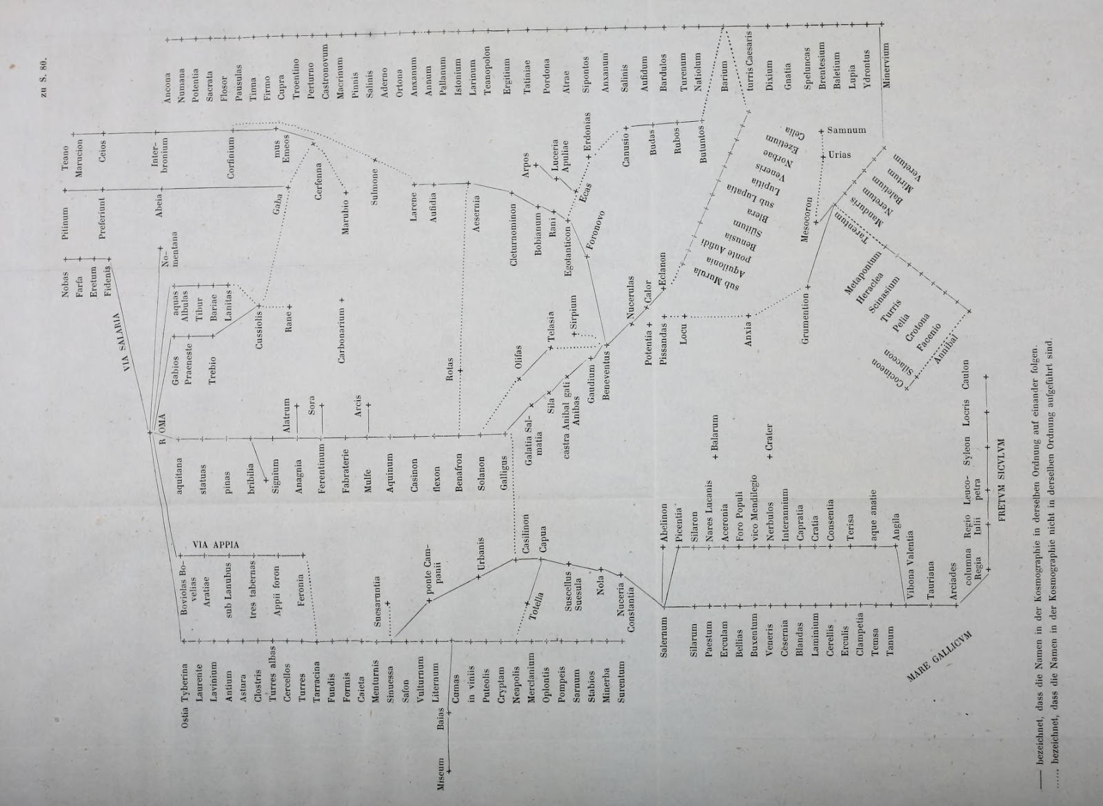
To make these system diagrams, I squeeze the Tabula like a concertina. The Tabula (surviving in a single manuscript, Vienna, Österreichische Nationalbibliothek, Codex Vindobonensis 324) is a very long roll, to be read in the horizontal. Eliminating that longness and adding some height enables us to see the network structure at a glance and comb apart the manuscript's jagged thickets of connections.

The limit of my squeezing is always the point where the slightly sloping lines in the original rear up to an angle of 45 degrees from the horizontal, since the most useful outcome is a spider diagram that resembles the London Underground network diagram. The horizontal scale is thus reduced and the crooked lines are regularized into a grid, but no other re-arranging is permissible.

One use of this assay procedure is to test how proportionate to the geographical landform the Tabula is. One can put the peninsula's outline on screen (anchored to Milan: press the radio button next to "landmass" to "on") and see that at one-fifth the width, the match is surprisingly good.

The grey shape you can see here is a silhouette of the coast which has been given a one-eighth turn so that the peninsula aligns horizontally. Look for the spur, heel and instep of Italy (the toe is out of sight). In the image above, you'll note that Naples (Neapoli) has been pushed too far downwards, and Rome and Benevento are placed too far to the right, but all in all, this mapping is closer to the real thing than the Underground diagram is to the real London.

I began with a proverb, all roads lead to Rome, which signifies that a variety of methods produce the same result. That is of course untrue in information visualization, where two different renderings of the same data - a scale map and a network diagram - often produce a very different impression on us.

The purpose of reflowing the Tabula in this fashion is to reveal some of its subtler graphic characteristics, which tend to escape notice when we stare at the roll-form original. The great Theodor Mommsen did something similar in 1851 before he became Germany's most famous professor. In his paper, ‘Die Unteritalien betreffenden Abschnitte der ravennatischen Kosmographie’, he rectified the Tabula layout much as I have done. (The job must have caused extreme stress to the printer.)

My systemic view is both more useful (with overlays and links) and more rigorous. You will notice in my analysis is that I have classified the roads into major (colored) routes with many stops (which I would argue derive from the original Tabula) and minor (black) cross-country routes with few stops, which are much more likely to be casual additions to the chart by later readers.

Reflowing will make features you have overlooked pop out visually. It may also reveal if you have misconceptions about the data. My first attempt at this stratification did expose a misconception. This concerned three land routes in southern Italy. The original Tabula shows Roma - Corfinio, Nares Lvcanas - Vibona Balentia (both olive green) and Erdonia - Gnatie (dark blue) as sinuous, fragmented, error-ridden routes. I mistook these for write-ins by a later user or editor.

The compressed version shows that if these routes are straightened out, they fit snugly enough into the available space. The road to Corfinio is a fairly important path across the Apennines, while the Nares - Vibona and Erdonia - Gnatie connections run parallel to (and quite close to) their respective coasts.

Of the remaining thin black lines, some represent now indeterminate sub-networks, such as near Hostilia, where the Tabula's original layout has been lost, or one or two borderline cases, such as a detour through Todo (Tvder), which may have been part of the first layout. But for the rest, I would argue they are no more than ancillary mark-up, not part of the primitive design.

I have already hinted at a related discovery: compared to the Mezzogiorno, a disproportionately greater width of the Tabula has been allocated to the parallel tracks from the Alps to Rome. Perhaps the chart-maker started at the left and ran out of room, but whatever the reason, the Mezzogiorno ended up being a crowded part of the chart where the three connections above had to be folded up to fit.

That in turn is a main reason why I could not compact the Tabula's southern Italy by a factor of more than 5, whereas it was feasible to compress the Tabula's Africa by a factor of 20. Compressing is done by opening an image of the Tabula in the Inkscape graphics program and using its Transform > Scale command to reduce the drawing to a stated percentage of its original width. Attempting to take Italia below 20 per cent caused some of the gently inclined paths to go nearly vertical.

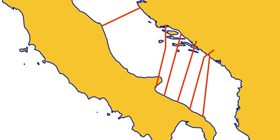
The disproportion between the two parts of Italy may disprove one of my earlier arguments too. In a draft article, I pointed out this year that across the Tabula's thin, river-like Adriatic, southern Italian cities are shown opposite Dalmatian coast cities that are almost due north of them.

The red lines in this sketch show these matches. From northern Italy, the one match shown involves the shortest line to the closest point, whereas five cities of southern Italy are not matched to the closest towns opposite. Knowing that the Mezzogiorno has been pushed into a space on the Tabula that is not big enough for it, we can guess this (rather than the African point of view) may explain the poor correspondences.

The Dutch scholar B. H. Stolte (see my missing manual) proposed nearly 70 years ago that the original Tabula was originally drawn scaled to one quarter of its present width. I am not entirely convinced by his argument, let alone his supposition that this applies to the whole chart, not just parts of it, although my system diagram demonstrates that compression is a possibility. I think it is simpler to assume that the chart-maker instinctively laid out most of his Italia lines either horizontally or at an incline of about 11 degrees, which would suffice to account for the neat, 45-degree compass rose of alignments when we compress the Italia zone of the chart.

We know now that the Tabula is not a "map" of the Roman Empire's road system. It leaves out too many major roads to merit that description. Its over-selects roads that run lengthwise on the roll and neglects the oblique ones.

I imagine the chart-maker planning his design with ostraca - old scraps of pottery or writing material - writing names on each from the itinerary texts and laying his scraps out in lines across the ground, a hypothesis I have already applied to the genesis of Great Stemma history diagram of antiquity.

Adopting the same approach as he had employed in Africa, the chart-maker drew the routes of northern Italia as parallel tracks (and indeed ignored all routes that were not longitudinal). These are the five or six main strands north (to the left) of Rome. These parallel routes shift and join like channels in an estuary, but the parallel reticulate pattern, as I call it, prevails. The Great North Road, the wine-red route from Rome via Fano and Bononia (Bologna), necessarily has kinks, since it crosses from Rome to the Adriatic coast, then turn north-west.

The routes in the Mezzogiorno turned out to be less parallel and more reticulate than in the north of Italy. In my spider diagram, the shore roads and the road parallel to each in the hinterland are easy to see, but it is the cross-peninsular routes that now catch the eye.

Two of these cross routes (purple and red) lead northeastwards from the port of Salerno to the "spur" of Italy, ending at Pescara (Ostia Eterni) and Siponto. These are not roads to Rome, but roads to use when avoiding Rome. If my hypothesis that the Tabula was drawn in Africa is correct, these would instruct any travelers from Africa heading over to the Adriatic coast.

There's another enhancement to my spider diagram which researchers may find useful. We only possess a single manuscript of the Tabula, but we possess a text that is half useful: the so-called Anonymous Cosmographer of Ravenna wrote a dreary listing of world place-names, probably in the 8th century, in which large sections match the name series in the Tabula.

The Cosmographia, which is the topic of Mommsen's paper already mentioned, does not directly help us to reconstruct the primitive version of the Tabula, which dates from five centuries earlier. But it does flag possible omissions or alterations in the Vienna manuscript. Because of its usefulness, I am offering an overlay where a brown line traces on the Tabula the places the Cosmographia mentions.

To make this useful to future researchers, I have marked the missing names with white circles. If you haven't found them yet, there are three controls in the top left corner of my system diagram (link again) which show and hide the layers: the spider layout, the outline of Italy, and the Cosmographia order. You simply need to click or tap the radio button controls. Try not to display more than one at once.

And where does "All roads lead to Rome" come from? The librarians at Notre Dame say:
The proverb "All roads lead to Rome" derives from medieval Latin. It was first recorded in writing in 1175 by Alain de Lille, a French theologian and poet, whose Liber Parabolarum renders it as 'mille viae ducunt homines per saecula Romam' (a thousand roads lead men forever to Rome). The first documented English use of the proverb occurs more than two hundred years later, in Geoffrey Chaucer's Astrolabe of 1391, where it appears as 'right as diverse pathes leden diverse folk the righte way to Rome.'

Mommsen, Theodor. ‘Die Unteritalien betreffenden Abschnitte der ravennatischen Kosmographie’. Berichte über die Verhandlungen der Sächsischen Akademie der Wissenschaft zu Leipzig, Philologisch-Historische Klasse 3 (1851): 80–117.

2017-05-17

Matteo's Grotesques

Matteo da Milano was a talented Italian illuminator working in the late 15th and early 16th centuries. Originally from Milan, he did most of his work in Rome and Ferrara for the Estes, the Medicis, the Orsini and the della Rovere families. His specialty was illustrating for the wealthy clerics from these ranking families and was noted for the borders which he decorated with grotesques, jewels, cameos and other all'antica features, carefully drawn flora and fauna (see article by Andreina Contessa).

You can see the style in S.Maria.Magg.12, a lovely music manuscript for use by the choir from Advent to Lent, made for Santa Maria Maggiore of Rome and now in the Vatican Library.

It is one of the latest codices digitized in color by the Vatican Library. My full list:
  1. Arch.Cap.S.Pietro.H.3.pt.bis, collection of materials on Shroud of Veronica. Curious because title page is got up like that of a printed book, indicating how dominant print style had become by 1616.
  2. Arch.Cap.S.Pietro.H.62, biographies. Paolo Vian has added a 2014 note at the front saying the catalog item dealing with this codex seems to be partly duff.
  3. Borg.ar.265
  4. Borgh.216
  5. Ott.lat.2862
  6. Reg.lat.243, miscellany with Augustine at ff. 1-53 (11th century)
  7. Reg.lat.261, 15th-century miscellany of Alcuin, Chrysostom and others
  8. Reg.lat.279
  9. Reg.lat.281, HT to @ParvaVox who recognizes this as a beautiful 9th-century manuscript of De vita contemplativa by Julianus Pomerius, copied by Agambaldus, monk and scribe.
  10. Reg.lat.299
  11. Reg.lat.328
  12. Reg.lat.339 : another HT to @ParvaVox who noticed a remarkable Carolingian stemma at fol. 7r in this 9th-century codex showing a funny-looking, cartoon-style Charlemagne and Louis the Pious. I will have to do some more digging to figure out where this belongs in stemma history: it's not a history book as such, but mainly a theology compilation.
  13. Reg.lat.346
  14. Reg.lat.372
  15. Reg.lat.435, Martyrologium, plus an interesting legal glossary at ff 41r-44v: Summula seu definitiones de legalibus verbis; 12th or 13th century French.
  16. S.Maria.Magg.12, magnificent 15th-century music codex (above)
  17. Urb.gr.120
  18. Urb.lat.320
  19. Urb.lat.859
  20. Urb.lat.1065.pt.1
  21. Urb.lat.1072.pt.2
  22. Urb.lat.1123
  23. Urb.lat.1225
  24. Urb.lat.1229
  25. Urb.lat.1230
  26. Urb.lat.1238
  27. Urb.lat.1222
  28. Urb.lat.1234
  29. Urb.lat.1239
  30. Urb.lat.1240
  31. Urb.lat.1246
  32. Urb.lat.1248
  33. Urb.lat.1256
  34. Urb.lat.1262
  35. Urb.lat.1772
  36. Vat.gr.86, black and white microfilm only
  37. Vat.gr.1702,
  38. Vat.lat.1040, eTK index of science manuscripts lists incipits Utrum de corpore mobili ad formam and Circa initium primi libri de generatione
  39. Vat.lat.1438, legal Bartholomew of Brixen and Bernardo Bottoni
  40. Vat.lat.2151, eTK index of science manuscripts lists incipit Prohemium huius libri continet duas of late medieval logician and metaphysician Walter Burley
  41. Vat.lat.6767
  42. Vat.sir.343
This is Piggin's Unofficial List number 116. If you have corrections or additions, please use the comments box below. Follow me on Twitter (@JBPiggin) for news of more additions to DigiVatLib.

2016-08-31

Men Who Wear Glasses

The Life of Francesco I del Rovere is a biography with a series of extraordinary illuminations depicting 16th-century court life in Italy.

Francesco Maria di Montefeltro was the fourth duke of Urbino and his life ended up being celebrated in word by Giovanni Battista Leoni and in images by Valerio Mariani da Pesaro. The manuscript, Urb.lat.1764, part of the Urbino Collection, was brought online on August 31 by the Vatican Library.

You can enjoy each of the images for a long time, and ask your own questions. Here's somebody standing behind the pope who is wearing natty black-rimmed spectacles. Explain that.

In 1524, Francesco paid a state visit to Venice and was met by the then Doge, Andrea Gritti, in the Piazzetta San Marco. Naturally there was a big procession for him:

But what caught my eye was the commerce at the fringe. Even in those days, there were jerrybuilt wooden shops on the main square of Venice selling heaven knows what to the tourists:

Enjoy browsing the manuscript. It is one of 39 just brought online for a new posted total of 5,353.  Here is my unofficial list:
  1. Reg.lat.1701, a fine miscellany from the 11th century. Among the contents is a glossary of Old High German with definitions in Latin. Below is the incipit of the Ars Poetica of Horace:
  2. Urb.lat.1764, discussed above
  3. Vat.ebr.4
  4. Vat.ebr.40
  5. Vat.ebr.41
  6. Vat.ebr.42
  7. Vat.ebr.344
  8. Vat.ebr.356
  9. Vat.ebr.390
  10. Vat.ebr.391
  11. Vat.ebr.392
  12. Vat.ebr.393
  13. Vat.ebr.394
  14. Vat.ebr.395
  15. Vat.ebr.397
  16. Vat.ebr.398
  17. Vat.ebr.404
  18. Vat.ebr.409
  19. Vat.ebr.410
  20. Vat.ebr.412.pt.3
  21. Vat.ebr.413
  22. Vat.ebr.420
  23. Vat.ebr.423
  24. Vat.lat.181
  25. Vat.lat.329
  26. Vat.lat.360
  27. Vat.lat.368
  28. Vat.lat.783
  29. Vat.lat.873
  30. Vat.lat.878
  31. Vat.lat.888
  32. Vat.lat.898
  33. Vat.lat.935
  34. Vat.lat.953
  35. Vat.lat.959
  36. Vat.lat.969
  37. Vat.lat.987
  38. Vat.lat.8552, Josephus, The Antiquities of the Jews, in Latin: check out the Latin Josephus Project for more information. This manuscript is discussed in a 1960 codicology book by Jacques Stiennon on millennial manuscripts from the Lieges area, reviewed in Scriptorium.
  39. Vat.turc.152
The Bibliotheca Palatina project is separately pouring on the power, and has brought the following 67 Pal.lat. manuscripts held by the Vatican online in recent weeks. The list includes a 9th- or 10th-century water-damaged Cassiodorus and a 10th-century Cicero with this fine initial C:
  1. Pal. lat. 761 Codicis Iustiniani imp. libri IX (1255)
  2. Pal. lat. 791 Iacobus de Alvarottus: Iacobi de Alvarottis patavini de feudis (15. Jh.)
  3. Pal. lat. 794 Sammelhandschrift (15. Jh.)
  4. Pal. lat. 800 (Iacobi) Gentilis (Brixiensis) repertorium iuris (Pars I) (15. Jh.)
  5. Pal. lat. 801 (Iacobi) Gentilis (Brixiensis) repertorium iuris (Pars II) (15. Jh.)
  6. Pal. lat. 802 Repertorium iuris (15. Jh.)
  7. Pal. lat. 803 Repertorium iuris canonici (15. Jh.)
  8. Pal. lat. 804 Tabula doctorum, i. e. repertorium universale iuridicum, theologicum, morale [Pars I] (15. Jh.)
  9. Pal. lat. 805 Tabula doctorum, i. e. repertorium universale iuridicum, theologicum, morale [Pars II] (15. Jh.)
  10. Pal. lat. 806 Repertorium universale iuridicum, theologicum, morale [Pars I] (15. Jh.)
  11. Pal. lat. 807 Repertorium iuris ; Conclusiones sexti libri decretalium (15. Jh.)
  12. Pal. lat. 808 Repertorium universale iuridicum, theologicum, morale [Pars III] (15. Jh.)
  13. Pal. lat. 809 Repertorium universale iuridicum, theologicum, morale [Pars VI] (15. Jh.)
  14. Pal. lat. 810 Repertorium universale iuridicum, theologicum, morale [Pars II] (15. Jh.)
  15. Pal. lat. 812 Repertorium universale iuridicum, theologicum, morale [Pars V] (15. Jh.)
  16. Pal. lat. 820 Mathey Palmery (sic) florentini de temporibus ad Petrum Cosmae filium medicem ; Eusebii (et) Hieronomi (sic) presbyteri chronica, a Prospero continuata (15. Jh.)
  17. Pal. lat. 821 Eusebii et Hieronymi chronicon, a Prospero continuatum (15. Jh.)
  18. Pal. lat. 823 Cassiodorii historia ecclesiastica tripartita (9.-10. Jh.)
  19. Pal. lat. 826 Anastasii Bibliothecarii historia ecclesiastica tripartita (11. Jh.)
  20. Pal. lat. 827 Pauli Horosii presbiteri ad Augustinum episcopum hystoriarum contra accusatores temporum christianorum, libri VII (13.-14. Jh.)
  21. Pal. lat. 828 Sammelhandschrift (11.,14., 15. Jh.)
  22. Pal. lat. 830 Mariani Scott chronicon (11. Jh.)
  23. Pal. lat. 832 Sammelhandschrift (14. Jh.)
  24. Pal. lat. 837 Ludolphi Carthusiani de uita Christi in euangelio tradita pars secunda et ultima (15. Jh.)
  25. Pal. lat. 838 (Ludolphi Carthusiani) de vita Ihesu in ewangelio (sic) tradita, pars prima (15. Jh.)
  26. Pal. lat. 844 Vitae patrum (15. Jh.)
  27. Pal. lat. 849 Jacobus : Legenda sanctorum (14. Jh.)
  28. Pal. lat. 918 Plutarchi vitae in latinum translatae (15. Jh.)
  29. Pal. lat. 928 Gesta Romanorum ; Historia septem sapientum (Süddeutschland, 14. Jh.)
  30. Pal. lat. 970 Giovanni ; Boccaccio, Giovanni: Sammelband (Italien, 1379 ; 15. Jh.)
  31. Pal. lat. 971 Honorius ; Johannes ; Petrus : Sammelhandschrift (Frankenthal, 1508)
  32. Pal. lat. 1093 Galenus: Sammelhandschrift (Italien, 14. Jh.)
  33. Pal. lat. 1095 Galenus: Sammelhandschrift (Italien (Südfrankreich), 14. Jh.)
  34. Pal. lat. 1099 Galenus; Avicenna; Albertus : Medizinische Sammelhandschrift ((Heidelberg), 2. Hälfte 15. Jh. (1475/77))
  35. Pal. lat. 1120 Avicenna; Knab, Erhardus: Fen quarta libri Canonis primi (Heidelberg, 1467)
  36. Pal. lat. 1183 Knab, Erhardus: Sammelhandschrift (Heidelberg, 1465/66)
  37. Pal. lat. 1232 Avicenna; Knab, Erhardus: Medizinischer Sammelband (Heidelberg, um 1470)
  38. Pal. lat. 1242 Ps.-Albertus Magnus; Odo ; Johannes : Medizinischer Sammelband (Südwestdeutschland , Freiburg (III), 14. Jh. (I) ; 1. Drittel 15. Jh. (II) ; 1419 (III) ; 1. Hälfte 15. Jh. (IV))
  39. Pal. lat. 1246 Avicenna; Thaddaeus; Gentilis : Medizinische Sammelhandschrift ((Heidelberg, 122ff.), letztes Drittel 15. Jh. (nach 1468))
  40. Pal. lat. 1263 Regimen sanitatis für Friedrich IV. von der Pfalz (Hedelberg, 1593)
  41. Pal. lat. 1274 Matthaeus : Circa instans seu de simplcibus medicinis (Westdeutschland, 13./14. Jh.)
  42. Pal. lat. 1310 Lanfrancus ; Ps.-Galenus: Sammelhandschrift (Montpellier, 14. Jh. (1325))
  43. Pal. lat. 1327 Laurentius Rusius; Iordanus ; Knab, Erhardus; Bartholomaeus de Montagnana; Zacharias de Feltris: Medizinische Sammelhandschrift (Heidelberg, 15. Jh. (1476-479))
  44. Pal. lat. 1334 Franciscus : Defensorium inviolatae virginitatis beatae Mariae (Blockbuch) (Regensburg, 1471)
  45. Pal. lat. 1360 Strabo: Strabonis Geographica (Deutschland, 2. Drittel 15. Jh.)
  46. Pal. lat. 1445 Leopoldus ; Yaḥya ibn Abi Manṣūr /al-Ma'mūnī; Hermes; Zael; Guido ; Albertus ; Johannes : Astrologische Sammelhandschrift: Miscellanea (Süddeutschland, Ende 15. Jh.)
  47. Pal. lat. 1480 Cicero, Marcus Tullius: Orationes (Italien, 15. Jh.)
  48. Pal. lat. 1484 Cicero, Marcus Tullius: Orationes (Italien, 15. Jh.)
  49. Pal. lat. 1497 Cicero, Marcus Tullius: Epistulae ad familiares (I-XVI) (Italien, 15. Jh.)
  50. Pal. lat. 1500 Cicero, Marcus Tullius: Epistulae ad familiares (I-XVI) (Italien, 14.-15. Jh.)
  51. Pal. lat. 1504 Cicero, Marcus Tullius: Epistulae ad familiares (I-XVI) (Italien, 14.-15. Jh.)
  52. Pal. lat. 1505 Cicero, Marcus Tullius: Epistulae ad familiares (I-VII, IX-XVI) (Italien, 15. Jh.)
  53. Pal. lat. 1506 Cicero, Marcus Tullius: Epistulae ad familiares (I-VII, IX-XVI) (Italien, 15. Jh.)
  54. Pal. lat. 1507 Cicero, Marcus Tullius: Epistulae ad familiares (I-XVI) (Italien, 15. Jh.)
  55. Pal. lat. 1514 Cicero, Marcus Tullius: Tusculanae disputationes (Italien, 10. Jh.)
  56. Pal. lat. 1566 Palladius, Rutilius Taurus Aemilianus: Opus agriculturae (Italien, 14. Jh.)
  57. Pal. lat. 1587 Sidonius, Gaius Sollius Apollinaris; Serenus, Quintus; Ps.-Crispus Mediolanensis Diaconus: Sammelhandschrift (Italien, 15. Jh.)
  58. Pal. lat. 1609 Erasmus, Desiderius: Enchiridion militis Christiani (Frankreich (?), nach 1574)
  59. Pal. lat. 1610 Oratio de natura leonis (Pfalz, um 1590-1594)
  60. Pal. lat. 1611 Guido : Sammelhandschrift (Italien, 13. Jh. ; 14. Jh.)
  61. Pal. lat. 1675 Francesco Ceccharelli: Commentum in Senecae tragoedias (Italien, um 1440)
  62. Pal. lat. 1730 Petrarca, Francesco: Sammelhandschrift (Italien (?), um 1440, 1442)
  63. Pal. lat. 1733 Gruterus, Janus: Anthologia (Heidelberg, 1602)
  64. Pal. lat. 1734 Carmina et orationes festivae (Cambridge, 1613)
  65. Pal. lat. 1744 Veit Örtel: Annotationes (Wittenberg, 1554-1557)
  66. Pal. lat. 1758 Gian Francesco Poggio Braccolini; Valla, Lorenzo (Deutschland, um 1465-1470)
  67. Pal. lat. 1823 Luther, Martin: Excerpta (Weimar (?), Mitte 16. Jh.)

This is Piggin's Unofficial List number 67. If you have corrections or additions, please use the comments box below. Follow me on Twitter (@JBPiggin) for news of more additions to Digita Vaticana.

2016-01-28

Bodmer Papyrus

A cache of 22 papyri, all apparently discovered and assembled in Egypt in 1952, was smuggled later to Switzerland to be sold for the highest possible price. This celebrated remnant of a library of the ancient world is named after Martin Bodmer, the wealthy scion of a Swiss silk manufacturing family, who purchased the papyri en bloc for his book collection at Cologny near Geneva.

Written in Greek, most are little codices, a few are rolls. Most of the ancient world's books have vanished, but the dry air of Egypt preserved just a few like these. The Biblioteca Apostolica Vaticana now holds several Bodmer Papyri of importance to Christianity.
One is an item known to scholarship as \mathfrak{P}72, a 3rd- or 4th-century manuscript. Part of it, containing sections of epistles Peter 1 and 2, was donated to Pope Paul VI in 1969. [My thanks to Brent Nongbri of Sydney (his page on Academia.edu) for explaining this to me.] Its BAV shelfmark is Papiri Bodmer VIII. The leaves have been unbound and each is kept in a glass frame. Its age naturally makes it a matter of interest in the debate on my blog last year about the world's oldest book.

P72 is celebrated enough to have its own Wikipedia entry with links that you can follow up. It came online on January 25, the first of the Bodmer Papyi to appear and one of the latest 136 Digita Vaticana releases. The images are dissimilar from the other scans and may simply come from the BAV's photographic collection. Previously, only some black-and-white microfilm images of this papyrus were accessible online via CSNTM.

My strictly unofficial list of the 136 releases is below (the BAV makes no running announcements), and I will add more annotations to this list as I have time. The links below lead to a BAV catalog page. You then have to click on book logo at the top left to see the actual digitization.
  1. Arch.Cap.S.Pietro.G.36,
  2. Arch.Cap.S.Pietro.H.46,
  3. Arch.Cap.S.Pietro.I.15,
  4. Barb.lat.4072,
  5. Barb.lat.4073, Dante
  6. Barb.lat.4079,
  7. Barb.lat.4087,
  8. Barb.lat.4098,
  9. Barb.lat.4116,
  10. Barb.lat.4117,
  11. Barb.lat.4119,
  12. Barb.lat.7943, charters, I see a date 1624 on one
  13. Barb.or.143,
  14. Barb.or.157,
  15. Borgh.226, Novels of Justinian
  16. Cappon.298,
  17. Chig.L.VIII.293, Dante?, annotations to verse
  18. Ott.lat.3316,
  19. Pal.gr.140,
  20. Pal.lat.23,
  21. Pal.lat.47,
  22. Pal.lat.965,
  23. Pal.lat.972,
  24. Pal.lat.974,
  25. Pal.lat.975,
  26. Pal.lat.976,
  27. Pal.lat.978,
  28. Pal.lat.980,
  29. Pal.lat.1207,
  30. Pal.lat.1276,
  31. Pal.lat.1351,
  32. Pal.lat.1362.pt.A,
  33. Pal.lat.1362.pt.B,
  34. Pal.lat.1365,
  35. Pal.lat.1400,
  36. Pal.lat.1418,
  37. Pal.lat.1424,
  38. Pal.lat.1447,
  39. Pal.lat.1459,
  40. Pal.lat.1463,
  41. Pal.lat.1464,
  42. Pal.lat.1465,
  43. Pal.lat.1472,
  44. Pal.lat.1475,
  45. Pal.lat.1479,
  46. Pal.lat.1483,
  47. Pal.lat.1486,
  48. Pal.lat.1488,
  49. Pal.lat.1489,
  50. Pap.Bodmer.VIII, see above
  51. Ross.463, just a few fragments of a lost 14th-century codex of Dante's Divine Comedy
  52. Urb.lat.13,
  53. Urb.lat.31,
  54. Urb.lat.52,
  55. Urb.lat.59,
  56. Urb.lat.99,
  57. Urb.lat.119,
  58. Urb.lat.120,
  59. Urb.lat.242,
  60. Urb.lat.272,
  61. Urb.lat.306,
  62. Urb.lat.312,
  63. Urb.lat.315,
  64. Urb.lat.324,
  65. Urb.lat.325,
  66. Urb.lat.326,
  67. Urb.lat.338,
  68. Urb.lat.340,
  69. Urb.lat.342,
  70. Urb.lat.344,
  71. Urb.lat.350, Aeneid by Virgil, see Rome Reborn catalog where Anthony Grafton opines (I am not sure why) that "this is perhaps the most lavishly illustrated of all copies of Virgil in existence." Here's a detail:
  72. Urb.lat.357,
  73. Urb.lat.362,
  74. Urb.lat.363,
  75. Urb.lat.364,
  76. Urb.lat.369,
  77. Urb.lat.377,
  78. Urb.lat.379,
  79. Urb.lat.380,
  80. Urb.lat.382,
  81. Urb.lat.386,
  82. Urb.lat.390,
  83. Urb.lat.391,
  84. Urb.lat.392,
  85. Urb.lat.393,
  86. Urb.lat.394,
  87. Urb.lat.395,
  88. Urb.lat.398,
  89. Urb.lat.399,
  90. Urb.lat.403,
  91. Urb.lat.404, papal bulls
  92. Urb.lat.408,
  93. Urb.lat.409,
  94. Urb.lat.414,
  95. Urb.lat.415, De Rebus Gestis Alexandri Magni of Q. Curtius Rufus (Life of Alexandra the Great) with this bad-tempered child faun at fol. 1r
  96. Urb.lat.419,
  97. Urb.lat.422,
  98. Urb.lat.424,
  99. Urb.lat.431,
  100. Urb.lat.436,
  101. Urb.lat.437,
  102. Urb.lat.440,
  103. Urb.lat.441,
  104. Urb.lat.455,
  105. Urb.lat.456,
  106. Urb.lat.459, Liber insularum archipelagi by Cristoforo Buondelmonti, a book of maps and account of the author's adventurous exploration of the islands of the Aegean in 1415 or so. The illustrations suggest the nostalgic and obsessive love for the classical past, notes Anthony Grafton's Rome Reborn catalog. See the St Louis catalog too. Here is Mytilene on Lesbos (fol. XXXr), 600 years before the current refugee wave was arriving on the island:
  107. Urb.lat.464, Florentine History by Leonardo Bruni, best-selling 15th-century author. See the St Louis catalog and Grafton's Rome Reborn catalog.
  108. Urb.lat.469,
  109. Urb.lat.471,
  110. Urb.lat.475,
  111. Urb.lat.480,
  112. Urb.lat.481, homilies of Ephraem the Syrian, Latin translation, and here he is:
  113. Urb.lat.482,
  114. Urb.lat.484,
  115. Urb.lat.486,
  116. Urb.lat.520,
  117. Urb.lat.682, Dante
  118. Vat.ar.2016,
  119. Vat.gr.2556,
  120. Vat.lat.28,
  121. Vat.lat.41,
  122. Vat.lat.48,
  123. Vat.lat.84, The Psalter of Nonantola (10th to 11th century), Beuron number 368
  124. Vat.lat.120, Gospels, with illumination by an artist of the Fécamp Bible
  125. Vat.lat.144,
  126. Vat.lat.242,
  127. Vat.lat.270,
  128. Vat.lat.389,
  129. Vat.lat.409,
  130. Vat.lat.459, Augustine, Confessions, 11th-12th century
  131. Vat.lat.471,
  132. Vat.lat.521, Humbert on Augustine, incipit "Viris religiosis non modicum ... "
  133. Vat.lat.4780, Dante
  134. Vat.lat.5465, an 8th or 9th-century Latin Gospel Book in uncial with fine Eusebian canon tables. The codicologist Michael Gorman (whose key article on the topic I have featured previously on this blog here and here) says it is one of a set of the southern Tuscan type, stating: "It seems to me that the abbey at Monte Amiata is a very probable origin for some of these manuscripts. We know of few likely alternatives." I have blogged on Monte Amiata here as well in case you are curious about the place itself. On canon tables, note Martin Wallraff's plans for an edition.
  135. Vat.lat.5691, Cardinal Cesare Baronio, 1538-1607, Annales ecclesiastici, vol. VIII
  136. Vat.lat.5758, Sermons of Augustine in one of the oldest manuscripts, made at Bobbio, Italy in the 6th or 7th century, see the catalog entry at St Louis. Lowe, CLA 1 36, TM 66131. It is marked on the front (p. 1) as coming from the book chest of Abbot Bobolenus. This pre-Carolingian homiliary is one of the sources of W. M. Lindsay's Notae Latinae covering abbreviations in the early minuscule period such as "ff kk" for "beloved brothers. Martin Hellmann is studying these. The codex also has some small but interesting initials, like this A on p. 95:
The posted total of items is 3,684 after one item, Vat.gr.126 was removed from the schedule for reasons unknown on Jan 28. If you have corrections or additions, please use the comments box below. Follow me on Twitter (@JBPiggin) for news of more additions to Digita Vaticana. [This is Piggin's Unofficial List 37.]

Gorman, Michael. “Manuscript Books at Monte Amiata in the Eleventh Century.” Scriptorium 56 (2002): 225–93: 268–71.

2016-01-19

Codex Benedictus

A fierce conflict between the Abbey of Fleury in France and the Abbey of Montecassino in Italy over which was the genuine resting place of the bones of Benedict of Nursia, founder of western monasticism, reached a high point in 1071 with the production in Italy of an elaborate illuminated lectionary that staked Montecassino's claim in art.

Known as the Codex Benedictus, this great work came online at Digita Vaticana on January 18. It was created for use on the feasts of saints Benedict, Maurus (Benedict's first disciple) and Scholastica (Benedict's sister). At Montecassino, they could not point to an actual tomb of Benedict, but they insisted he lay somewhere in the abbey precincts.

The making of the codex, which features 66 large and colourful miniatures of Benedict's life, was supervised by Abbot Desiderius (1058-1086) who composed part of the text and had himself pictured on the dedication page, folio IIr, handing over this tribute to the long-dead Benedict himself. An inscription reads: Cum domibus miros plures pater accipe libros.

Among the scenes is Benedict showing to a younger monk, Servandus, the world from a high tower as angels fly past the window carrying the soul of a bishop, Germanus (folio LXXIVv). This is a re-interpretation of Benedict's often-quoted dream of having seen the world from a heavenly perspective, which can be read in Gregory the Great's Dialogues 2.35.

Gregory puts an interpretation on Benedict's report of viewing the "whole world" from the tower which Patrick Gautier Dalché considers tantamount to a Late Antique theory of visualization:
The soul of him who sees in this manner is above itself; for being rapt up in the light of God, it is inwardly in itself enlarged above itself, and when it is so exalted and looks downward, then it comprehends how little all that is, which before in former baseness it could not comprehend. (Gardner translation).
On folio LXXXr is an image of Benedict's Entombment (below). The codex, which also contains texts by Alberic of Montecassino, features many smaller details and initials.

An elaborate facsimile of it was published in 1981 as an expensive collectible. Now you can enjoy it for free. For a comprehensive and excellent introduction to the codex and these images, read John Wickstrom's 1998 article, Pope Gregory's  Life of St. Benedict and the Illustrations of Abbot Desiderius of Monte Cassino, on Academia.edu.

Digita Vaticana's new posted total of manuscripts after the 55 uploads on January 18, 2016 is 3,549. The secret list of new arrivals (which I compiled using spot-the-difference software) is below, whereby I will leave the Pal.lat. series undiscussed, as they have been public in Germany for some time.
  1. Barb.lat.4409, architectural drawings of the Vatican by Domenico Castelli
  2. Borgh.280, Anonymous: Summarium sive Breviarium super Decretum, 14th century
  3. Cappon.313.pt.A, architectural engravings of Rome
  4. Pal.lat.636,
  5. Pal.lat.697,
  6. Pal.lat.943,
  7. Pal.lat.944,
  8. Pal.lat.945,
  9. Pal.lat.947,
  10. Pal.lat.948,
  11. Pal.lat.949,
  12. Pal.lat.959,
  13. Pal.lat.960,
  14. Pal.lat.961,
  15. Pal.lat.964,
  16. Pal.lat.968,
  17. Pal.lat.981,
  18. Pal.lat.982,
  19. Pal.lat.983,
  20. Pal.lat.984,
  21. Pal.lat.985,
  22. Pal.lat.986,
  23. Pal.lat.988,
  24. Pal.lat.1060,
  25. Pal.lat.1094,
  26. Pal.lat.1098,
  27. Pal.lat.1102,
  28. Pal.lat.1112,
  29. Pal.lat.1113,
  30. Pal.lat.1136,
  31. Pal.lat.1181,
  32. Pal.lat.1202,
  33. Urb.lat.92, Bernard of Clairvaux's letter against Peter Abelard
  34. Urb.lat.155, civil law commentary by Roffredo Epiphanius and Bonaguida
  35. Urb.lat.167, William Durandus and Bartolus de Saxoferrato
  36. Urb.lat.177, Roland Passagerus
  37. Urb.lat.184, Aristotle, Physics, etc.
  38. Urb.lat.236, Galen, Avicenna, etc, in a 14th-century manuscript
  39. Urb.lat.275,
  40. Urb.lat.288,
  41. Urb.lat.301, a revision of Cornucopia, a mid-15th century commentary on Martial by Niccolò Perotti. This featured in the Rome Reborn exhibition in the mid-1990s in the United States, where Anthony Grafton's catalog notes: Later the work was revised and expanded by Perotti's son Pyrrhus.
  42. Urb.lat.311,
  43. Urb.lat.319, Cicero, 15th-century ms.
  44. Urb.lat.321, ditto
  45. Urb.lat.331, Petrarch, 15th-century ms.
  46. Urb.lat.332, ditto
  47. Urb.lat.333, ditto
  48. Urb.lat.334, Petrarch, De remediis utriusque fortunae
  49. Urb.lat.343, Plautus, comedies
  50. Urb.lat.355, Seneca, tragedies
  51. Urb.lat.356, ditto
  52. Urb.lat.368, anthology of poetry and fables, 15th century, full contents copiously listed by Stornajolo's catalog
  53. Urb.lat.373, poetry by Porcelli and others, 15th century
  54. Urb.lat.402, writings by Piccolomini before he became Pope Pius II, 15th century
  55. Vat.lat.1202, the Codex Benedictus (above)
Here's a silly monkey that thinks it can hide behind a tiny and leafless tree (detail of folio 1r of Urb. lat.373):

If you have corrections or additions, please use the comments box below. Follow me on Twitter (@JBPiggin) for news of more additions to Digita Vaticana. [This is Piggin's Unofficial List 36.]

Gautier Dalché, Patrick. “L’Héritage Antique de Cartographie Médiévale: Les Problèmes de les Acquis.” In Cartography in Antiquity and the Middle Ages: Fresh Perspectives, New Methods, edited by Richard J. A. Talbert and Richard Watson Unger. Leiden: Brill, 2008.