Showing posts with label Italy. Show all posts

2016-01-08

His and Hers

Our latest investigation concerns a curious courtroom scene possibly drawn by Nicolò da Bologna in Urb.lat.160 at folio 5r. I introduced this manuscript in November 2015 when it was brought online by Digita Vaticana. The St Louis catalog discusses the codex in some detail, as does Stornajolo's Codices Urbinates Latini, Codices 1-500, pp 166-167.

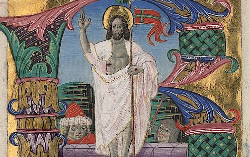
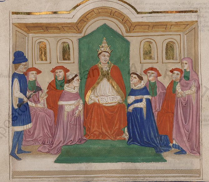
The caption under the scene says "Bonifatius". The miniature appears on the opening page of the Liber Sextus, a compilation of decretals issued under the authority of Pope Bonifatius (Boniface) VIII in 1298. The text on the two columns of this manuscript page has not been fully set up in print since 1582 but can be easily read in a reproduction in the UCLA Digital Collections here at the UCLA Library.

The manuscript dates from about 1380, but the anonymous St Louis cataloger thinks the art may be from 50 years later, noting "The Liber Sextus appears to be written around the same time, but its decoration was probably executed in the 15th century, around 1420-1440, in northern Italy, perhaps Ferrara."

Who is the man in the blue tunic on the far left of the image? My interpretation of the scene is that it shows Bonifatius at centre consulting his law book. Kneeling in front of him are two advocates. The advocate at right is pointing to the woman and is apparently speaking on her behalf. The left advocate appears to represent the man in the blue hat. The setting is Renaissance Italy.

It would be plausible to suppose the two litigants are husband and wife, as couples were frequent parties in canonical courts. The other four seated men in red hats appear to be part of the panel of judges. They are evidently listening to what is being said. The room is low and has a daytime garden visible through the four windows, but that is probably an artistic framing device only, not a real location.

What is going on? The man in blue on the left is scowling. The woman has drawn up her skirt to expose her hem, her blue-slippered foot and an ankle. Perhaps she is avowing she has nothing to hide. @zippyman818 notes that her white/blue garment is the opposite in decoration to the man's blue/white combination at the hem, which must symbolize some irreconcilable difference.

Both man and woman are wearing blue slippers. They are both clearly well-off. And here is the big question: what is the man holding?
It's black, it has a bulb at the bottom left end and it looks as if it is about 60 centimetres long. @zippyman818 and I have been having some fun in a Twitter exchange (expand from this one to see the whole conversation) trying to work out the puzzle.

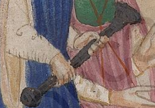
The first consideration is whether it might be a gun. The first firearm in Europe was the arquebus, and I read that it was employed in the army of Matthias Corvinus, which might get us back to a date of 1460. But this image long predates that, and in any case the object does not have a hook, which is essential to cope with gun recoil (and muzzle loading), and the bulb cannot have a function in any firearm.

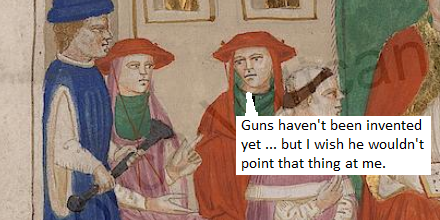
Another early answer was a horn, but there is no mouthpiece on the thing. Again the bulb is the puzzle. It's not a klaxon, as rubber bulbs had not been invented. Besides why would a rich litigant take a horn to court? @zippyman818 has also suggested a long-handed chisel or a herb cutter with a mezzaluna blade, but again, why would the pope let you bring one into his courtroom?

[A completely different approach proposes that the object is ceremonial in nature. The arguments are set out in the comments below. Armin argues that it is a sconce, a kind of torch (in case the trial goes on past nightfall?) Ilya Graubart is proposing a mace (if medieval popes had armies, perhaps they had maces or sceptres as well). These arguments would suggest that Mr Blue Tunic is not a litigant, but maybe the pope's majordomo or some other papal panjandrum.]

It has been suggested the black thing might be an artistic emblem identifying some historic person who sought justice from the real-life jurist Bonifatius, or a speaking stick entitling the person to hold the floor, but Blue Tunic's mouth is shut. Or it might be a ritual object like an aspergillum or some entirely forgotten symbol.

My own tendency is believe it is an item of evidence connected to a marital lawsuit, perhaps a sword scabbard. Is the wife being accused of adultery with the sword's owner perhaps? At this point we become fanciful. But clearly, when the miniature was drawn, this object was immediately recognizable and perhaps it even elicited a laugh from the Renaissance reader.

2015-11-03

Oldest Family Tree

As part of my book research, I am searching for the oldest family tree. Some time in the 16th century, the idea of dressing up the genealogies of royal and noble families to look like oak trees took hold in Europe. These were printed from copper engravings and could be distributed to regional leaderships as a kind of corporate branding and loyalty-building exercise.

As an entrepreneurial venture, this could be profitable. Scipione Ammirato, the Italian writer and historian, set up a workshop in Florence and turned out a whole series of them in cooperation with artist-engravers (Congedo, 216). On spec, he sent a family tree of Henry III to the French royal court. He received a reward of 500 gold ducats from Paris for it (Congedo, 274).

The oldest of Ammirato's trees is probably that of the Hapsburgs of Austria, engraved in 1576. It shows the tree on a high hill over a bay (probably representing Trieste) where a great naval fleet rides at anchor. The original copper plate still exists in Florence, according to the Italian register of cultural heritage, though it is not stated who owns it. An original print from it was sold by the antiquarian bookseller Gonnelli a few years ago as part of a set for 300 euros:

The type continues with Ammirato's 1580 book Delle Famiglie Nobili Napoletane. which contains eight double-page and five single-page engraved illustrations of genealogical trees. Each contains some kind of landscape in the background that can be connected with the dynasty. Here is my plot of part of the tree of Marzani, who were big shots in the Spanish-ruled Kingdom of Naples, from that book:
Now I must hasten to say that what I am looking for here is the earliest example of a thing named "family tree" or "albero genealogico" or "Stammbaum" or "arbre de famille".

We know from the great study by Christiane Klapisch-Zuber that these things had unwitting precursors in previous centuries. There were even 12th-century artists who took pre-existing stemmata and flipped them upside down to depict them as trees. A celebrated example, now at Erlangen (Universitätsbibliothek ms 406, fol. 204v), is found in one of the manuscripts of the Chronicle of Ekkehard of Aura:
But these were experiments or flukes, not genealogical trees as a general cultural phenomenon.

The conscious idea of presenting a complete family line connected by a woody trunk first shows up in southern German woodcuts in the late 15th century. [Later note: Dr Volker Bauer (see below) has kindly pointed out a magnificent early example in BSB incunable 2 Inc.s.a. 1264 from 1475-78 digitized here (seek image 18) and also at the LOC. There is also a most remarkable tree of heraldic arms in the 1492 Cronecken der Sassen, GW 4963.] This phenomenon reaches its finest flower in the Ehrenpforte engraved in 1515 by Albrecht Dürer (there's a fine reconstruction of this on Virtuelles Kupferstichkabinett). But Dürer's has no branches.

The tree as a recognizable category of art, a product where artist and customer know what to expect, only shows up later in the sixteenth century. It looks semi-natural, has a bottom root and clearly tiered generations. The oldest example I can find is Robert Peril's 1535 tree of the Hapsburgs made at Antwerp (lower half online: Boijmans Collection).

Examples later than Ammirato's include a fine 1586 tree of the Kings of Saxony by Lorenz Faust which is labelled "Stammbaum," perhaps the first documented use of that word in the German language (the link is to the MDZ in Munich). [Later: Note however a 1515 illustration title "Bawm vnnd Außlegung der Sypschafft ..." here.] The type's later development in Germany and embrace of tree shapes other than oaks has been researched by Volker Bauer of the Herzog August Bibliothek.

But I cannot find any trees of living families from the first third of the 16th century. Has anyone got suggestions?

Ammirato, Scipione. Delle Famiglie Nobili Napoletane. Firenze: Appresso Giorgio Marescotti, 1580. https://archive.org/details/gri_33125013895186.
Bauer, Volker. “Attesting to Dynasty: The Use of Images in Early Modern German Genealogy.” Rome, 2013. http://crhipa.upmf-grenoble.fr/wp-content/uploads/2015/04/Bauer.pdf.
———. “Dynastic Botany: Banyans, Cedars, and Palms as Visual Models in Seventeenth-Century Genealogy.” In Visual-Acuity-and-the-Arts-of-Communication-in-Early-Modern-Germany, edited by Jeffrey Chipps Smith. Ashgate, 2014. https://www.ashgate.com/pdf/SamplePages/Visual-Acuity-and-the-Arts-of-Communication-in-Early-Modern-Germany-Intro.pdf.
Congedo, Umberto. La vita e le opere di Scipione Ammirato (notizie e ricerche). V. Vecchi, 1904. http://archive.org/details/lavitaeleopered00conggoog.
Klapisch-Zuber, Christiane. L’Ombre des Ancetres. Paris: Fayard, 2000.
———. “The Genesis of the Family Tree.” In I Tatti Studies. Essays in the Renaissance, 4:105–29. Florence: Leo Olschki, 1991.

2015-02-28

Hungary's Week in Rome

This was a special week for Renaissance studies in Hungary. An extraordinary book of art, the Hungarian Angevin Legendary, Vat. lat. 8541, arrived on the web, as I pointed out in an earlier post. With it were two important illuminated missals associated with the lost Bibliotheca Corviniana, the library of Hungarian King Matthias Corvinus (1458-1490). One, Urb. lat. 110, was made for the king in 1488 and is known as the Missal of Matthias Corvinus. The other, Ross. 1164, was pointed out by and is known as the Franciscan Missal. Below is an image from Urb. lat. 110 of a silver-skinned Christ at the resurrection.
has written a blog post introducing the two missals and I am grateful to him for the information about this group.

Two fine French Renaissance manuscripts were also brought online, both of them French translations of Latin works. One is Reg. lat. 538, a translation of the Speculum Historiale, a medieval history of the world, by Vincent of Beauvais, and there is a wonderful image in it where the artist imagines Vincent calmly writing while research assistants or socciii struggle to keep up with his demands for more books. There's a bit more about it here. There is a similar codex at the British Library.
Also newly digitised is Reg. lat. 719, a translation by Pierre Bersuire from the Latin of Livy's History of Rome. The Bersuire book has a wonderful imaginary landscape of ancient Rome (below) as a medieval artist might imagine it with a river through a paradise of green that looks most un-Roman. Both these codices are principally of interest for their illuminations rather than their text.
Finally, I took note of a couple of more modern documents from Italy. A book of caricatures by Pier Leone Ghezzi (1674-1755), Ott. lat. 3113, marks out Ghezzi's extraordinary talent as a cartoonist. Look at the fleshy marchese at left in this image and you see his whole life of over-indulgence.
Also in my pick is a curious compilation, Reg. lat. 1468, of Italian family coats of arms (a thing which happens, by the way, to be called a "stemma" in Italian, which is not very logical, but that is the way it is). Here is an escutcheon which has three men's heads looking left on a mustard field. The different chin shapes are doubtless just a fancy of the artist.
In all, 64 new codices were digitized and published online on Digita Vaticana this week. Something else I sighted in this rush was a pair of large sheets from Vat. lat. 9848. It is no more than a wild guess, but these folios seems to be either sketches or tracings of monumental art, possibly from a Rome church. All that's online are these two sheets, recto and verso. Also new, but merely noted, is Ott. lat. 2919, a book of hours. [This is Piggin's Unofficial List 3.]

Portolan Charts of Pietro Vesconte

Among the finest things to be made available online this week from the Biblioteca Apostolica Vaticana (BAV) digitization programme in Rome is a codex, Vat. lat. 2972, which contains portolan charts which though unsigned can be reliably attributed to the remarkable mapmaker Pietro Vesconte and dated to about 1320.

Portolan charts are, for all intents and purposes, the first true western maps. Everything that precedes them, ought, in my view, to be classed as geographical diagrams.

A portolan chart was something novel and unprecedented, showing the world deskewed and to scale. Geographical diagrams like the BL's Psalter Map of 1265 (see this flash version) showed the human world as mentally represented. By contrast, portolan charts, with compass lines superimposed, show the physical world as one navigates it, with the entire coastline of a sea fully labelled without regard for the social standing of the places on the coast. When a vessel is trapped by a landward wind, any of the places here offers a potential haven on a lee shore. The Vat. lat. 2972 codex contains an atlas of five sheets and is part of Marino Sanudo's Liber secretorum, a book devoted to a mad plot to destroy the Muslim world. Here is the atlas version of the English Channel (folio 110v):
In the middle you see Dumqerqo (Dunkirk), Gravallinga (Gravelines), Calles (Calais) and Bellogna (Boulogne), and at right Parissius (Paris) and Cam (Caen).

Tony Campbell, former map librarian of the British Library, wrote a fine descriptive summary about portolan charts earlier in February on the Pelagios blog while presenting the portolan component of the Pelagios project. He tells us at least one portolan chart from the very end of the 13th century survives. The BAV's, from just two decades later in 1320, will likely become a prime reference on the internet. Yale has a later chart from 1403 online.

Curiously, Genoa-born Vesconte also did mappaemundi similar to that in the Psalter Map. He was on the cusp of the transition from old to new. Here are the British Isles in his Vat. lat. 2972 mappamundi. Since this map (112v) has east at its top, Ireland (Ybernia) is at the bottom of this grouping:

Update

I have tried to tag all the places on the continental coast in the portolan chart above, but some defeat me. Here is what I have resolved, after consulting Campbell's general toponymic listing:
#Bruges
? (Cavo Sta Catalina identified as Pointe de Zand by Campbell. Not clear what St Catherine's; the source document would have been Portuguese.)
#Oostende
#Nieuwpoort
#Dunkerque
#Gravelines
#Calais
#Wissant
#Boulogne
#Étaples
? (vapa identified by Campbell as Port St. Quentin or Eu.)
#Dieppe
#Fécamp
? (no port marked; Campbell proposes Chef de Caux)
? (no port marked, so "loira" may be an inland place)
#Quillebeuf
#Harfleur (on wrong side of Seine!)
#Honfleur
#Touques
#Caen
#Ouistreham

Some of these ports no longer exist, the rivers having later silted up and become unnavigable, leaving coastal areas that today are mainly a zone of holiday beaches.

Tony Campbell published a major new article on March 2, 2015 on the Carte Pisane, which is traditionally regarded as the oldest portolan chart, but is now the focus of controversy. He sets out arguments as to why it should be dated to the very end of the 13th century.

2015-02-17

Is this the world's oldest bound book?

This was the week when the Vatican's library, the BAV, made available online digital images of what is perhaps the world's oldest intact, large, bound book, the Codex Vaticanus. It contains a handwritten text on 759 vellum leaves and is generally estimated to have been made in the second quarter of the fourth century (325–350 CE).

That it survives is amazing. That no one noticed what the Vatican was doing is almost more amazing. But more about that later.

During the 19th century, the BAV customarily only allowed visitors to touch this treasure under guard, so great was the fear that it would be stolen or damaged by a religious fanatic. Scholars grumbled at this, but the librarian's suspicions were not ill-founded. That anybody with web access can now read it without a couple of muscular young clergymen staring at the back of their neck as if they were a terrorist is a wonderful transformation.

The codex contains the Christian Old and New Testament in Greek and is comparable in age and significance with the Codex Sinaiticus, which got its own lush online presentation five years ago.

One can toss up as to whether the Vaticanus or the Sinaiticus is the oldest substantial bound book in existence, but the Vaticanus is the one in better shape, since it is still in one binding. The Sinaiticus got dismembered in the 19th century by the sort of scholar that the Vatican wisely never trusted (see above) and is now divided between four countries.

Neither book has a production date on it, so their ages can only be guessed from palaeographic evidence. Wikipedia's substantial description argues Vaticanus contains more antiquated features and is the older of the two, although one scholar, T.C. Skeat, propounded a theory that the two codices are contemporary and both come from the Late Antique scriptorium of Eusebius of Caesarea.

At the start of this post, I said the codex may be the oldest bound book. The qualification is important since books as we now know can come in three forms: scroll, codex and e-book.

I would have seen my first e-book at the Frankfurt Book Fair about 30 years ago and thought it a strange new thing, and the first owner of the Codex Vaticanus might have seen his first codex used for a scholarly purpose and thought it was a strange thing 30 years before he commissioned this very special codex for himself.

It is generally suggested that codices -- that is, books made of flat pages between two boards, bound at a spine -- began to outnumber the earlier technology, the scroll, in about 300 CE.

So "books" older than the Codex Vaticanus do survive: in scroll form, or as isolated pages torn from codices, among them the Chester Beatty papyri. But if you were to ask me where to find the world's oldest book -- meaning a thing between two covers, which is what most of us would mean -- I would point you to Rome, BAV, Vat. gr. 1209. Look at it and marvel.

On February 16, 2015, the BAV added 31 new items to its stock of online digitizations, raising the total volumes so far to 1,626. The collections added to were Arch. Cap. S. Pietro (10), Borgh. (5), Ott. lat. (1), Sbath. (1), Vat. ebr. (6), Vat. gr. (1, the Codex Vaticanus), Vat. lat. (4) and Vat. turc. (3).

Items in the enormous Vat. lat. series which are newly available are Vat. lat. 83, which is a fine collation of hymns and psalms from the 11th century. It has a wonderful illumination in it of David with harp and the other supposed writers of the psalms, among them Ethan in a sailor suit (right), each with quill and ink-horn and a nifty little mobile desk of the sort that court writers must have used in the 11th century.

Tracking down the psalm authors had always been a matter of interest to Jewish and Christian scholars as we know from my edition of the fifth-century Liber Genealogus.

Also online for the first time are a book catalogue (Vat. lat. 3970) by Cardinal Sirleto (1514-85), a biography of Saint Gerard (Vat. lat. 7660), and a wonderful scrapbook of fragments (Vat. lat. 13501) presumably extracted from old bindings where we see a great variety of writing styles, a palimpsest or two, bits of sheet music and everything else that would have been hurled out in library spring cleanings and landed in this or that medieval book binder's recycling bin.

Sadly, the Vatican Library does not have the time or resources to promote this amazing release. To get in the news nowadays, you need a mass murder, a scandal or PR hype. The sole publicity for the release of the Codex Vaticanus was one modest tweet. Yes, a twiddling, tiny tweet. I suppose that all of the digital project's funds must go into actually scanning the books and getting the files into the servers.

I will keep a continuing watch on what they are digitizing in such honorable secrecy and present an occasional summary on this blog or on my Twitter feed. [This is Piggin's Unofficial List 1.] If you know of anyone else tracking the BAV digitization project, I would be happy to contact them.  Follow this blog, or follow me on Twitter @JBPiggin and I will keep you up to date.

This post originally ended with some debate on the "oldest bound book" hypothesis, but since that material grew so long, I have moved it to a separate blog post.

2015-01-23

Vatican Libary Making Progress

There are signs at last that the Vatican Library's manuscript digitization program is making good progress: there are now 1,549 manuscripts of the Biblioteca Apostolica Vaticana available online (up from 1,503 on January 1, a gain of 3 per cent in just 3 weeks).

The index page, which previously, listed every single digitization, has got so unwieldy that it has now been reduced to a compact, top-level, springboard page listing the collections the project has touched so far.

There's no sign yet of Vat. lat. 5729, the colorfully and richly illuminated Bible of Ripoll, which I want to see. So far only 78 of more than 15,000 medieval and modern items from that collection have been digitized. But the progress makes me optimistic.

UPDATE: After a couple more jumps (30 new items on February 4 alone), the total is 1,595. (And how do I know? Because I checked yesterday and today.)

2014-03-06

Florence Online Again Soon?

Last year I described the wreck of the Laurenziana Digital Library in Italy. This was to libraries what the Costa Concordia sinking was to shipping, except that there was no craven captain involved.

There seem to be some faint stirrings of life in the wreck of one of the world's great medieval manuscript collections. There is no announcement on the portal of the Biblioteca Medicea Laurenziana about any fix, but on Wednesday at breakfast time, I briefly managed to access a manuscript in the Biblioteca Digitale. They are no longer using the ill-conceived Java set-up, but serving pages with their own URLs, just as Archive.org does.

This must have been a test only by the engineers, because for the rest of the day and today I have obtained a 503 error only.

There is a touching honesty about the site: the site map asks us to report 404 errors if we see them:
Questo sito è continuamente aggiornato e verificato in modo da evitare link scorretti e fastidiosi Error 404.Vi saremo molto grati se vorrete segnalarci errori.
But a 503 is not a 404. Can we hope that the digital library will be online again soon? Is anyone able to obtain access? Or has anyone seen a blog post about this?

2013-12-07

Java Disaster in Florence

The digital library of 3,000-plus manuscripts at the Medicea Laurenziana Library in Florence was introduced on this blog as outstanding news three years ago. This year, disaster struck as hackers round the world exploited security vulnerabilities in Java software. Java's security had to be tightened to such a degree that the current plug-ins for browsers can no longer access the digital library in Florence.

This mess has been evident for several weeks. The library has just issued a notice about the problem which offers little solace other than a promise to act in "a short space of time" to achieve a permanent solution. The notice (digitally dated December 6) blames "security controls in the latest version of the Java interpreter that no longer allow the execution of our viewer."

The interim solution proposed is not satisfactory: uninstalling your current Java version and downgrading to the old low-security version, SE 6, which is "still compatible with our application".

Oracle warns that this version is "not recommended for use" and is reserved for developers and administrators doing debugging. Running an unsafe Java version would, in my view, only be feasible if you were to reserve a dedicated computer to visit the Laurentian site alone. Otherwise the risk would be too great of catching a virus while the PC was used to visit other parts of the internet. And who has computers to spare?

2013-07-08

Bridge at Blumau

In a post one year ago, I described the ancient road through the Eisack gorge in the north of Italy. The other day I took a closer look at its major surviving Roman feature, the Bridge at Blumau or Prato all'Isarco. In this post I will use the German name of the town, since this community is in a German-speaking area.

As I have already explained, this road possessed enormous geopolitical importance, providing the quickest communication route to move troops, intelligence, materiel and goods between Germania and Italia through the Alps. One might argue that every bridge on this north-south route possessed equal importance, but the Blumau crossing, deep inside a narrow, obstructed gorge, was surely the most challenging and most expensive to build, maintain and defend.

Other important crossings like that at Waidbruck (Ponte Gardena) could be re-sited, or may even have had back-ups, but the Bridge at Blumau was quite simply irreplaceable: there was almost no other position at Blumau in which it could be be placed, and pontoons could not be used. Without the bridge, this all-seasons route would have been impassable. Any north-south communication, weather permitting, would have required at least an extra day via the Ritten Plateau or Völs route, or at least three extra days, via the more westerly Via Claudia Augusta over the 1,500-metre Reschen Pass. See my map.

All that remains of the bridge today is a stone abutment, which stands on the left or south bank of the river. This important monument is not signposted in any way, and it is fairly difficult to get a view of. You can lean right out from the parapet of the existing concrete bridge and see at least part of the stonework from above (in the bottom left quarter of this picture, which you can enlarge by clicking):

A better view is obtained by driving down an asphalted lane on the right bank, and scrambling over steep loose soil to the water's edge, down-river from the bridge. Here it is possible to stand on a sandbank and peer through fronds of trees, obtaining a view of how the abutment curves up into the beginning of an arch. Eight layers of stone remain. It may be that some of the collapsed bridge is still here in the river-bed.

The next picture shows the structure, with the arch of a 20th-century concrete bridge above it. The remains are in shadow at the centre of the picture. It might have been better to wait all day until the sunlight was not so bright and then take a picture, but my dear wife and son came along for this expedition and we had some other pleasures such as hiking to also accomplish that day, so this picture will have to do:

Probably the most recent professional description of one of Late Antiquity's most neuralgic sites is that by Vittorio Galliazzo, the great scholarly authority on Roman bridges, who examined the structure in 1999. I do not know much Italian, so I have used Bing and Google Translate to essay the following rough translation from pages 64-65 of his 2002 article, Ponti e Forme di Attraversamento di Corsi d’Acqua dell’Alto Adige in Età Romana. Please let me know if you can improve or correct the translation:
Near a site that has already yielded a milestone from the reign of Maxentius (CIL V 8054 = 463 IBR), the left abutment of an ancient bridge on the old road through the Eisack Valley, together with a section of an arch almost up to its waist, was found in 1930 about 5 kilometres east of Bolzano during reconstruction of a bridge that forms part of the Brenner Highway. Further investigation at the end of 1988 by Dr. Lorenzo Dal Ri of the Archaeological Heritage Office of Bolzano Province confirmed that these remains were probably Roman. An architect, Andrea Perin, subsequently suggested his own reconstruction in a sketch based on the scant reliable information available and a good deal of hypothesis.
From the details that follow, one understands what an engineering challenge the structure posed for its designers and builders: it  had to cross high-volume rapids that are susceptible to flash floods. Land access to the cramped site is blocked from north and south. No boats could be used. A huge wooden frame had to be assembled to hold the large number of wedgestones during construction.
No piles could be driven: the footings had to be carved out of solid rock.

The section that follows is awkward to follow without any picture, so I have inserted letters into Galliazzo's account in square brackets, so that you can see in this detail from my photo which layers he is talking about:

The abutment is approximately 4.50 m wide at its base and consists of four rows of blocks of compact yellowish stone of modest thickness [B1, B2, B3, B4] which protrude on the upstream side, as if to form a protective flank with the aid of the carefully modelled porphyry stone of the riverbank. The abutment is fitted into a cavity specially hollowed out of the dark porphyry rock [P] on the left bank, evened out as need be with sandstone slabs. The sector of arch, which is about 4 metres wide, tops this support structure and likewise consists of yellowish blocks of porphyry. One sees four rows of wedge-stones, three of them [A1, A2, A3] nearly intact and one fragmented [A4].
All the surviving structure of the abutment is in big chiselled blocks, tied with leaded iron clamps. Several stones, especially the upstream ones in the third and fourth row [B3, B4], have rusticated faces with listello or refesso drafted margins. The arch segment appears to have had an intrados in opus vittatum consisting of rather small blocks joined with hard lime.
From what I could see directly during a first inspection in 1994 and a subsequent survey in 1999, the first row from the bottom in the remaining sector of the arch [A1], that is to say counting up from the join, comprised four quadrangular, regularly dimensioned blocks, with a fifth flanking them upstream while a sixth downstream from them was tailored to fit into the “living” rock. This layer was surely used at the time of construction to support a hoop-shaped wooden scaffold and then probably re-used as the footing for the wooden beams of the later medieval bridge, which was no longer a stone arch but probably a wooden truss (i.e. a series of vertical stays supporting a horizontal wooden superstructure). At about 10 and 21 metres respectively from this ancient abutment, you can see the remains of two piers in the bed of the Eisack River on which uprights of the scaffolding for the boxing to construct the 1928-1930 concrete bridge stood before they collapsed.
Galliazo's article includes two black and white photographs evidently taken in winter when there was less vegetation obscuring the view. He also reproduces Perin's sketch although he repudiates its veracity. Galliazzo concludes with the following general assessment of the structure:
It seems that the whole bridge, from abutment to abutment, had a length of about 33-34 metres which could be feasibly crossed not with three arches as has been proposed in the draft reconstruction, but with just two asymmetrical arches. This would result in a bridge similar to that at Merano with arches supported on sturdy abutments built into the rock of the banks and one pier of considerable proportions outside the river current: the greater of the two arches would have been on the left of the river and would have needed to have a length of about 18-20 meters to straddle the channel, while the lesser arch would have had an opening of less than 8 meters and would have probably provided an extra discharge during floods to better withstand the water pressure.
As regards the dating of the structure, the arrangement of the stone blocks and the overall impression given by the remnant of the abutment would suggest engineering of the Imperial if not of the Late Antique period, perhaps replacing an earlier bridge in wood, a material that was very abundant in the region. The collapse of this structure must have occurred by the Middle Ages, since the medieval timber replacement can be dated in all likelihood to the first half of the fourteenth century. It would seem to date from between 1314, when Count Heinrich of Tyrol commissioned the entrepreneur H. Kunter by contract to open an Eisack valley trail, the Kuntersweg, and 1390, when a document includes mention of construction of a bridge at Blumau.
It is notable that Galliazzo rejects the hypothesis that the structure could be the Pons Drusi which is marked on the Peutinger Diagram but in no other documentary source. He and other authors of the Südtirol archaeology volume consider the Pons Drusi to have been a bridge in the heart of Bolzano.

I took only rough notes from his bibliography and have not read these further materials, so I apologize that I must offer these references here with incomplete titles. The 1930 report at page 366 of Archivio per l'Alto Adige that first pointed to the existence of these remains should also be added to this reading list:

Dal Ri, Lorenzo. “?Title unknown.” In La Venetia nell’area padano-danubiana: le vie di comunicazione: Convegno internazionale: Papers, edited by Guido Rosada. Padova: CEDAM, 1990. See 620-621.

Galliazzo, Vittorio. I ponti romani. Vol. 1. 2 vols. Treviso: Canova, 1995. See 149, 249, 399.

———. “Ponti e Forme di Attraversamento di Corsi d’Acqua dell’Alto Adige in Età Romana.” In Archäologie der Römerzeit in Südtirol. Beiträge und Forschungen. Forschungen zur Denkmalpflege in Südtirol, edited by Lorenzo Dal Ri and S. Di Stefano, 57-71. 1, 2002. [The article quoted in this post.]

———. , ed. Via Claudia Augusta: un’arteria alle origini dell’Europa: ipotesi, problemi, prospettive : atti del Convegno internazionale Feltre 24-25 settembre 1999. Comune di Feltre, 2002. See 233, 236.

Olivi, M. “?Title unknown (‘Strada Romana Bolzano-Ponte Gardena’ or similar).” Archeologia Veneta 7 (1984). See 256-257.

Tabarelli, Gian Maria. Strade Romane nel Trentino e nell’Alto Adige. Trento: Temi Ed., 1994. See 122-125.

Regrettably, this very important structure is not yet included (at the time of this posting) in Wikipedia's List of Roman Bridges.

2012-12-22

The Amiata Stemma

We can be quite certain that a copy of the Great Stemma was at the Benedictine Monastery of San Salvatore on Monte Amiata in Italy in the eleventh century, because it inspired an author-artist on the mountain to attempt his own adaptation of it, "correcting" it, abridging it and extending its content up to "modern" times.

In this update, the structure and essential text of the diagram were retained, but most of the stemmata that fill its central space were discarded and replaced by a vast tableau of successive rulers of the western world in 128 roundels, spanning fifteen centuries from Darius the Great to Henry III. The latter name allows us to date this document, because Henry III must have been the current Holy Roman Emperor when this remix was laboriously copied by the scribes onto four blank folios at the back of a book of commentaries by great theologians on books of the Old Testament. Henry III ruled Germany and Italy between 1039 and 1056. His year of death is added in another hand to a list of kings elsewhere in the same codex.

This graphic adaptation of the Great Stemma scheme for a new age must have existed in multiple copies, but we only possess one of them,which has been penned into a codex which was made and kept at Monte Amiata and is preserved today in the Laurentian Library in Florence under the name Codex Amiatinus 3. The diagram spanning eight pages (ff. 169r-172v) in Amiatinus 3 is demonstrably not the original, because the artist evidently laid out his first draft on a wide scroll, and that is how I have sketched it here:

It is not too difficult to prove that the drawing now spread over eight pages must have once occupied a single sheet. The tableau of 128 kings, which is designed to be read left-to-right in eight rows of sixteen roundels, has been split and placed on two sides of a folio. This obliges a reader who wants to read it in historical order to continuously turn the page back and forth: a situation which would never have been intended by the artist. The split is merely the consequence of sectioning the overall diagram into frames so that it would fit in a codex.

In the above plot, I have drawn a black rectangle around the 128 historic rulers of the west. The succession (it makes many wild jumps) comprises Achaemenid rulers, emperors of Rome, kings of Italy and Holy Roman Emperors. Some of the authors below perceive this as a documentary forerunner to the translatio imperii doctrine.

It is conceivable that this remix (which dispenses with most of the stemmata except for the families of Adam and Isaac) was compiled before Henry III came to power, and was merely updated to keep up to date with changes in political control. The revision contains a list of popes which the scribe has not bothered to update. This roll-call of the papacy ends with Agapitus (pontificate 946-955), so it is conceivable that the re-drawing took place in the middle of the tenth century.

Very little has been published about this document, although a plot of it, not quite as accurate as mine, appeared some years ago in an article by Gert Melville. The latter two authors below appear not to have realized that the abbey possessed a copy of the Great Stemma from Spain which mentions the Visigothic King Wamba. None of them explore the theological position of the Amiata drawing, which rejects the Joachimite account of Jesus's ancestry and restores an orthodox genealogy that exactly follows the text of the Luke Gospel with 42 generations from David to Christ via Nathan.

Gorman, Michael. ‘Manuscript Books at Monte Amiata in the Eleventh Century’. Scriptorium 56 (2002): 225–293: 268–271. Lists the contents of Amiatinus 3 and discusses the Amiata scriptorium. See my earlier discussion of this article in respect of the Liber Genealogus.

Klapisch-Zuber, Christiane. L’ombre des ancêtres. Paris: Fayard, 2000. Discusses the Amiata Stemma at pp. 72-73.

Melville, Gert. ‘Geschichte in graphischer Gestalt. Beobachtungen zu einer spätmittelalterlichen Darstellungsweise’. In Geschichtsschreibung und Geschichtesbewusstsein im späten Mittelalter, edited by Hans Patze, 57–154. Vorträge und Forschungen / Konstanzer Arbeitskreis für Mittelalterliche Geschichte 31. Sigmaringen [Germany]: Thorbecke, 1987. Contains a drawing of the Amiata Stemma on a fold-out, making clear that Melville also interpreted it as a single-page diagram. Given the work that went into the plot, one is surprised by the brevity of the discussion at pp. 66-67.

2012-12-21

Cyclopaedia

The Florence copy of the Great Stemma appears in a codex which seems to be an idiosyncratic scrapbook containing snatches of ancient things. I described in an earlier post how Michael Gorman reconstructed its putative source, a library book at Monte Amiata that doubtless had as its title work the Etymologiae, a copious dictionary of legal, religious and other terms by Isidore of Seville, the seventh-century Spanish bishop.

A good many blank pages had evidently been left free at the end of the Monte Amiata copy of the dictionary, and a monkish user, perhaps a teacher or an abbot, had used them as a kind of scrapbook, copying into them a personal miscellany of the sort of items often formerly appended to dictionaries: a guide to syllables, vowels and consonants; Bede's alphabetical directory of Latin grammar exceptions; how to study the bible; the list of Lombard kings; brief repetititions from the Etymologiae; four different chronologies of biblical time; and our diagram.

Seen on its own, each item seems absurdly and wilfully truncated, but if one assumes that its learned user only copied what he really needed - the things he could not easily remember - this begins to make sense. The items belong to a class of things that in my student days I would have photocopied and kept on a window-sill, and that I might now scan and tuck into a miscellaneous folder on my computer.

The book by Junilius, for example, is a collection of thoughts about bible education written in 551 CE and seemingly aimed at a teaching audience. It was published and comprehensively discussed by Kihn (link below to archive.org). John F. Collins prepared a 20th century introduction and English translation, now on James O'Donnell's Cassidorus website.

Other items in this anthology are intended handbook-style for the classroom or self-study.

An illuminating dissertation by Carin Ruff translates sample sections of Bede's De Orthographia and stresses  that it was mainly written to instruct the intermediate student of Latin in the many exceptions of usage and declension in Latin grammar. It is in alphabetical order of keywords. It sets out for example verbs that take the dative. A sample:
Noceo, obsum, incommodo, maleficio, officio, in una significatione ponuntur, quod graece dicitur βλάπτω, et cuncta datiuum casum trahunt. (Noceo, obsum, incommodo, maleficio, officio, are used in one sense (“hinder”), which in Greek is βλάπτω, and they all take the dative case. Translation by Ruff.)
You can read this on the 10th line of the left column of folio 12v of the Florence manuscript Plutei 20.54 (the scribe seems to have got the Greek wrong). Ruff quotes a suggestion that the intended audience for Bede's manual was "the less-experienced copyist or glossator who might 'be dissuaded from making a rash emendation' if he could find an apparently anomalous reading discussed in a readily accessible manual."

The inclusion of four or more contradictory chronologies should not suggest the book's owner had a burning interest in chronography or in resolving the differences among them. Quite the opposite: he clearly wanted something comprehensive which he could look up when he came across a seeming error in a book, resolve quickly whether the anomaly had a genuine source or was merely a "typo" and then move on. He seems to have regarded the Liber Genealogus as a handy quick guide to biblical names and the Great Stemma doubtless served for him a similar purpose.

I deliberately term the Etymologiae here a dictionary, although it is conventionally termed an encyclopaedia, because our modern conception is that an encylopaedia should summarize scientific and scholarly knowledge whereas a dictionary is mainly an aid to finding and correctly spelling the words with which we write about such things. The Monte Amiata handbook must have been much more the second of these things, and it occurs to me that I had just such a book when I was a school pupil and student: Pears Cyclopaedia.

When I first began working as an editor at dpa in the 1980s, the newsroom had no ready references and I arranged for the purchase of a Pears and a Quid. Both had their heyday before the internet and were useful to editors and proofreaders who faced all sorts of unexpected dilemmas over correcting texts and needed this kind of omnibus collection of seemingly useless facts. The cyclopaedia, which is subtitled "A Book of Background Information for Reference for Everyday Use" and was conceived in the medieval spirit as something in between a modern encycylopaedia and a handbook, begins with a chronicle of events from the formation of the Earth.

The appendices to the Monte Amiata copy of the dictionary were probably accumulated with a similar intent: not to transport the texts themselves (which are only excerpted and are largely offered without the necessary metadata such as author's names) but simply to have key facts close to hand. It is interesting that not even a very erudite later owner of Plutei 20.54, Coluccio Salutati, seems to have realized that the handlist of Latin exceptions was a work of Bede, although Coluccio was familiar with Bede's church history. Coluccio began writing out the headwords of the alphabetical list, but only got as far as C and never finished. He never attached the author's name to the list, and his own Latin doubtless became solid enough that he no longer needed such an intermediate-level reference for himself.

Kihn, Heinrich. Theodor von Mopsuestia und Junilius Africanus als Exegeten : nebst einer kritischen Textausgabe von des letzteren Instituta regularia divinae legis. Freiburg: Herder, 1880. Archive.org. Edition and discussion of a work found near the Great Stemma in a codex in Florence.

Ruff, Carin. ‘The Hidden Curriculum: Syntax in Anglo-Saxon Latin Teaching’. University of Toronto, 2001. Website. Usefully translates samples from and discusses Bede’s De orthographia. Follow link to dissertation, go to chapter 4, which is a PDF containing Part II, section 2.

2012-12-01

Books, Books, Books

I have just refreshed the bibliography on the Great Stemma which now runs to more than 180 items. The  major change is that it is now annotated, following the urging of Phoebe Acheson of the University of Georgia (Athens) Miller Learning Center, who founded the Ancient World Open Bibliographies (AWOL). She added the original bibliography to her list in May 2011, where it is tagged under both information architecture and paragraphy.

Additions include the article by Helena de Carlos which I recently posted about as well as a rather shallow discussion by Carlos Miranda in 2000 of the differences between the Great Stemma, Lesser Stemma and Compendium of Peter of Poitiers:
Miranda García, Carlos. ‘Mnemonics and Pedagogy in the Compendium Historiae in Genealogia Christi by Peter of Poitiers’. In Genealogia Christi, edited by Maria Algàs, translated by Anne Barton de Mayer, 29–89. Barcelona: Moleiro, 2000.

This appears in a very interesting volume devoted to a Rome manuscript in roll form of the Compendium. To my astonishment this is quite a rare book: there is only one copy as far as I know in any research or public library in the north of Germany (and only two in the south, at Passau and Munich). As an insert, it contains a printing of what I would guess is the first-ever digital plot of a medieval stemmatic diagram. The work on this very impressive poster-style, fold-out sheet is credited in the book (page 15) to Enrique de Castillo. I will give it a bibliographic reference of its own when I do a medieval book-list.

2012-11-12

An Abbey on an Extinct Volcano

Google Street View enables a virtual visit to the Abbadia San Salvatore at Monte Amiata, Italy which was mentioned a few months ago in this blog as the source of three outstanding medieval codices.

The abbey was suppressed in 1782 in consequence of a scandal involving Filippo Pieri, the last abbot, his brother who was also a monk and their live-in girl friend, who had become pregnant. The account, quoted by Michael Gorman, includes an outraged duke denouncing the monks for their "airy, careless, protected, ignorant, liberal" ways and the public scandal they sowed.

A religious community was re-established in 1939, but as far as I can see on the internet, it is no longer there. A municipal website for the town, which took over the name from the religious community, provides no further useful information. Elsewhere, I find an imperfectly translated history of the site and photos including:


Monte Amiata is reckoned at 1,738 metres to be the second-highest volcano in Italy, but is now extinct and covered with forest. The abbey and its town are on the mountain flank, not the top (Roberto Ardigo photo):

2012-07-10

In the Eisack Valley

I am in northern Italy looking out a hotel window at the Dolomite mountains and I am considering the feasibility of a passage through this countryside by Queen Cunigunde of Germany in November 1013 on her way to Rome to be crowned as Empress of the West. My flight of imagination has been prompted by Cunigunde’s ancestral stemma: back in March, I published a vector translation of it. It can be found both on this blog and on Piggin.Net. The original, the oldest extant stemma of a real-life family, was drawn up at some point between 1002 and 1024 to emphasize the queen's claim to imperial rank. It would be plausible to believe that she took this parchment drawing with her in her baggage when she passed through this landscape with her husband Henry and the imperial army.

Reconstructing the route used 1,000 years ago by Henry and Cunigunde is not easy. The main stops on the trip can be established from the Regesta Imperii, the summary, formerly printed and now online, of extant legal documents issued during the travels of the Holy Roman Emperors. Unlike the papal regesta, which were registers (the modern spelling) of correspondence compiled contemporaneously by papal secretaries, the imperial regesta are reconstructions: modern tabulations compiled by historians from widely scattered documents in archives. It is fairly plain from the regesta that Cunigunde, Henry and the army conducted a two-month crossing via the Brenner Pass from Augsburg in Germany to Pavia, capital of the Lombard kingdom of northern Italy, arriving in time for Christmas after being held up by floods in northern Italy.

November is perilously late in the season for an alpine crossing, even if you are in command of an imperial German army sworn to ensure your absolute safety. As winter approaches, the snowline is descending and the hours of daylight are growing short. Approached via Innsbruck, Austria from the north, the Brenner Pass is the lowest saddle in the main alpine watershed and therefore the safest track to use in late autumn. After crossing it at an elevation of only 1,370 metres, well below the treeline, the medieval track then descended toward Italy, following the valley of the Eisack (or Isarco) River. The principal impediment to the king, queen and their army - the size of this host is not recorded - was not the pass, but a 20-kilometre gorge further south where the Eisack rushes between towering rocky slopes and narrows at least twice between stony gates before reaching a wide plain at Bozen (Bolzano).

The archaeologists Laura Allavena Silverio and G. Rizzi (see the bibliography below) have presented evidence that the preferred prehistoric detour around this rugged barrier was a path on the left bank of the Eisack that rose to nearly 1,000 metres' altitude to circumvent two ravines, passing via the settlements of Seis and Völs and returning to the valley floor at Blumau (I will use German place-names since the majority population of the location today is German-speaking).

I have drawn a map showing the approximate course of this path (the river outline comes from OpenStreetMap). The prehistoric path - via Seis - is formed by a brown line. It can be see that it continues down the valley crossing two very difficult bluffs, the Gallibichl and the Hochklause. It may be that Cunigunde and Henry used this track, but as we will see, there was at least one other option.

The Kuntersweg and two other ancient roads through the Eisack Valley

Early in the 3rd century, the Romans built a deviation through the gorge stretching from Kollmann to Blumau. It was no doubt a marvel of engineering, employing two bridges, at Waidbruck and Blumau. These allowed the road to change from the left to the right bank and back to the left to take advantage of the most favourable footing. Other smaller bridges were needed to cross tributaries of the main river. It is represented by the red line on the map.

The entire Kollmann-Bozen road through the valley is known as the Kuntersweg in honour of a late medieval restoration of the Roman route by an enterprising businessman, Heinrich Kunter, and it still remains in use, somewhat widened and straightened with the help of tunnels, as the SS12, an Italian national highway. 

Engineers have progressively widened the gorge in the past thousand years to also accommodate a double-track railway, an autostrada (the Brenner Autobahn) and a cycleway and we no longer see much of the Roman/medieval riverside track, but close attention from a car gives some idea of the obstacles that had to be negotiated. Proceeding downstream, the gorge becomes twisting from Atzwang onwards. In an image on Google Street View (slow loading!), one can see why a tunnel had to be built for today's freeway: there is simply no space in the valley at the left of the picture to accommodate a wide road. 

 It is not uniformly narrow. There are quite a few wide places in the gorge: But in its original state, there were also many gatelike points where the river slipped through fissures and the steep mountain walls left little room for any road. These rock formations jutting into the river's course were the principle obstacles to transit in the prehistoric, Roman and medieval period. I have already mentioned the two located just west of Blumau: the Gallibichl and the Hochklause. From the lie of the river and the location of settlements, I suspect there were formerly such gate points at Atzwang and Steg, but if so they have been quarried away.

This route from Blumau to Kardaun is described in detail by the historian Norbert Mumelter in his brief survey of the Kuntersweg (see the bibliography below). Until explosives were used for the first time in 1607-1608 to blast the Gallibichl and Hochklause, there was no way round these bluffs and they had to be surmounted by steep tracks rising high above the valley floor. Perhaps the Romans operated some kind of mansio (travellers' rest with spare horses for hire) at these bluffs to provide teams of additional horses, mules or oxen to draw carts up the inclines and lower them without crashing on the other side. Kunter and his successors certainly did. Centuries of civil engineering have been needed to defeat these obstacles. Here are some images (slow loading!) from Google Street View and Bing Street Side, firstly of the much diminished Gallibichl:
and secondly of the Hochklause:
  • from the east, punctured by the highway tunnel with a small vineyard on top
  • the ledge road that was begun in 1607-1608 at the water's edge
  • an aerial view showing the vineyard and the two roads.

The existence of any Roman-era deviation along the floor of the gorge has been sometimes doubted, but Allavena Silverio and Rizzi have recently published detailed evidence for it, stating that the remains of the Roman bridge near Blumau are still clearly visible. Segmentum IV of the Peutinger Map (original or redrawn, link at right to Talbert) displays the Roman road through the Eisack Valley with the stops Vepiteno - 35 - Sublabione - 13 - Pontedrusi. The unusually short, 13-mile stage between Sublabione (Klausen, number 275,5 in the Antonine Itinerary) and Pontedrusi (Bozen) is an indication that although not much ground was covered, it was a particularly difficult stage which could occupy a complete day to travel. Mansio Sebatum, the newly opened museum of Roman roads at St Lorenzen, includes the gorge road on its map (much more detailed than the Peutinger) of the Roman-era road network in the area.

However the very knowledge that a Roman road had existed before Kunter's engineers set to work seems to have been lost until the discovery in about 1500 of a Roman milestone on or near the Gallibichl. The engraving on the stone names the soldier-emperor Maxentius and can thus be dated to about 310 CE (Mumelter, 28). It may be that Kunter's business model was to revive Roman roads while giving the impression that he was designer of highways through virgin territory: Mumelter mentions other trade roads with the name Kuntersweg in Austria which may have also been makeovers of Roman routes by Kunter or his relations.

The state in 1013 of the Roman road through the Eisack gorge is impossible to determine. With the abdication of the last western emperor, Romulus Augustus, in 476 and the takeover of Italy by the Germanic warlord Odoacer, Roman imperial control of the Italian highway system ceased, at least in the formal sense that the administration was "imperial". The Ostrogothic kingdom of Italy which succeeded the Empire here may have conducted some minimal maintenance of its roads. The Carolingian empire probably applied funds to maintain one or other heerstrasse since major highways remained a key to political control.

However it can be assumed with good reason that the Roman deviation had become impassable by 1013. As soon as either of the bridges at its endpoints (at Waidbruck or Blumau) collapsed, the road would have become a cul-de-sac. The Eisack is too swift to cross by ferry or fording. Even if that had not happened, the lesser bridges or embankments may have been washed out by floods. Or a rockslide may have ripped away one of the ledges on which the road was built. Or else the road may have been deliberately wrecked in the course of warfare during the five centuries prior to Cunigunde's and Henry's passage.

Whatever happened, it is plain that medieval regional governments lacked the resources - and perhaps the motivation - to tend such a high-maintenance road over the span of more than eight centuries until Kunter arrived on the scene and obtained his concession on 1314 September 22 to clear a footpath through the gorge for pedestrians, mounted travellers, packhorses and cattle. He plainly followed the same route as the Romans had used, restoring the bridges at Waidbruck and Blumau and adding a third crossing at Kardaun, the Feigenbrücke, so that the road could end in the city of Bozen. But in time, Kunter's road also eroded away, prompting a dramatic description by a German priest, Felix Faber, of the terrors of negotiating it (in Latin, quoted by Mumelter). Faber described the sheer drop to his right and a rock wall pressing on his left, as he made his way along the left bank of the gorge towards Jerusalem in April 1480.

Back in Cunigunde's day, large military formations arriving in the region via the Brenner Pass may well have proceeded along the left-bank route following the mountain slope via Seis and Völs, but it is generally believed that medieval Rome-bound German imperial convoys routinely adopted a third route, cutting their way across the Ritten Plateau on the right bank of the Eisack River, 900 metres higher than Bozen. The principal evidence for this alternative upland detour is the existence from about 1200 (long after Cunigunde's passage) of a hospice for travellers at Lengmoos, 1,164 metres above sea level, the highest point of the crossing. After the (re-)opening of the Kuntersweg, traffic across the plateau tailed off and the hospice was converted into a feudal manor of the Teutonic Order of Knights. The current building, the Kommende, dates from the 17th century, and nowadays hosts an open-air theatre show every summer. The exact Ritten route is poorly documented, but is generally held to have begun (when heading downstream) at Kollmann, rising gradually to the plateau via Lengstein, then steeply descending to Rentsch, a suburb of Bozen, joining up with what was later to become Kunter's highway. 

Allavena Silverio and Rizzi advance the reasonable argument that the upland roads on both the left bank and right bank are not only extremely ancient, but that they remained well trodden even when the Roman road led through the gorge in Late Antiquity. A bare track might easily remain in use despite the existence of a well maintained imperial road or heerstrasse in the vicinity. Incentives for certain travellers to "go a different way" would have included avoiding surveillance, tolls and customs duties. Moreover, historians point out that the Roman legions and the cursus publicus always had a prior claim on use of the main road. Besides, the road over the Atwzang, Steg, Gallibichl and Hochklause may never have been safe for heavy carts with wider wheelbases. It may be that the Ritten route was compulsory for "heavy goods vehicles". Near Lengmoos are rocks which local antiquarians say have become rutted from being passed over by countless iron wheels over the centuries.

In terms of altitude, a crossing of the Ritten Plateau was every bit as arduous as crossing the Brenner Pass, but it may not have been as unappealing to the medieval traveller as we might be inclined to think. In our day we assume that the best road is one that reaches its objective with a modest gradient. But this judgement is conditioned by our constant use of motorized vehicles, whether they are cars or trains. When vehicles were drawn by beasts, steep gradients might be accepted because the ideal road was hard-surfaced and free of hairpin bends: stony soil, dry ridgeways, holloways and corduroy were employed so that carts did not bog down or overturn. When the traffic was limbed - pedestrians, mounts and cattle - roads could be even steeper, resembling flights of stairs: the ideal road was the least number of strides where one could maintain a foothold, even if it led up a cliff. 

Last week I tried out the latter class of "good" road: a steep track ascending the 850 metres from Steg, on the edge of the Eisack River up to Klobenstein, which is just above Lengmoos. Klobenstein is the principal town on the Ritten Plateau. Our party of three needed five hours in summer weather with the temperature above 30 degrees celsius to complete the ascent, though the signboard at the start at Steg suggested hikers in good physical condition ought to manage it in half the time. I was nevertheless surprised that the climb could be accomplished in just a morning, and I suppose a complete army could have been taken up such a hill within the space of a day. Our route had of course been cleared for us. The only obstacles were long grass, nettles and sometimes slippery gravel. The track passed the ruins of Burg Stein, a 13th-century castle. In the farmed areas higher up the ascent, the steep path is paved with big, rough stones, probably dating from the 18th or 19th centuries. One supposes that horses were often lashed to death by carters and peasants as the draught teams struggled to haul loads up such routes.

Cunigunde of course saw no castles: the era when Europe's main routes of travel became lined with fortresses was centuries in the future. There were also no paved tracks up the mountain. The royal party, their force of mounted knights and foot-soldiers and all their pack animals probably left the valley floor at Kollmann to gradually climb through the chilly woods to the Ritten Plateau following a route that is still in use today as a narrow, winding, asphalted country road. It would not have been signposted or blazed. The party probably had to rely on local guides or some other form of pilot. 

The queen may not have found the ascent and descent physically strenuous, since she probably rode on one or more palfreys, but it is likely to have been psychologically disturbing to her. 

Modern tourists enjoy the grandeur of the scenery as seen from the Ritten Plateau: a vast, cold grey block of stone, the Schlern, flanked by jagged pinnacles, rises to an altitude of 2,500 metres. Dense evergreen forests, dotted with giant boulders, spill down to the river edge. But to a medieval German queen, the whole scene would have been fearsome and chilling, with the effect heightened by the cold and the fear of attack by enemies or wild beasts. The sheer strangeness of the landscape with the jagged, pale grey crags of the Dolomites seeming so close at hand would have unnerved and frightened her. In the foreground she may well have seen the Ritten's fields of fairy chimneys: bizarre towers of soft rock, many of them five to ten metres high. Each of these pinnacles is topped by a round, hard boulder which has protected the stone below it from erosion by rain. Medieval travellers were told (and believed that) the boulders had been lifted onto the pinnacles by playful giants.

After the exhausting ascent on horseback to Lengmoos, where the army would have set up camp in some more or less level clearing on the plateau, collecting dry timber from the woods for fires and perhaps stealing livestock for food from any peasants who had not fled in time, Cunigunde had to steel herself for the vertigo of a slithering 900-metre vertical descent by an even steeper muddy track from the plateau to the alluvial plain where the Eisack river flows into the Adige river. Her transit of the Alps was neither picturesque nor enjoyable.

Further Reading

Allavena Silverio, Laura, and G Rizzi. ‘La strada romana di Elvas nella viabilità antica della Valle Isarco’. In Archäologie der Römerzeit in Südtirol. Beiträge und Forschungen. Forschungen zur Denkmalpflege in Südtirol, edited by L Dal Ri and S Di Stefano, 511–. 1, 2002.

Mumelter, Norbert. Der Kuntersweg. Bozen: Gemeinde Karneid, 1986.