In a
post one year ago, I described the ancient road through the Eisack gorge in the north of Italy. The other day I took a closer look at its major surviving Roman feature, the Bridge at Blumau or Prato all'Isarco. In this post I will use the German name of the town, since this community is in a German-speaking area.
As I have already explained, this road possessed enormous geopolitical importance, providing the quickest communication route to move troops, intelligence, materiel and goods between Germania and Italia through the Alps. One might argue that
every bridge on this north-south route possessed equal importance, but the Blumau crossing, deep inside a narrow, obstructed gorge, was surely the most challenging and most expensive to build, maintain and defend.
Other important crossings like that at Waidbruck (Ponte Gardena) could be re-sited, or may even have had back-ups, but the Bridge at Blumau was quite simply irreplaceable: there was almost no other position at Blumau in which it could be be placed, and pontoons could not be used. Without the bridge, this all-seasons route would have been impassable. Any north-south communication, weather permitting, would have required at least an extra day via the Ritten Plateau or Völs route, or at least three extra days, via the more westerly Via Claudia Augusta over the 1,500-metre Reschen Pass. See my
map.
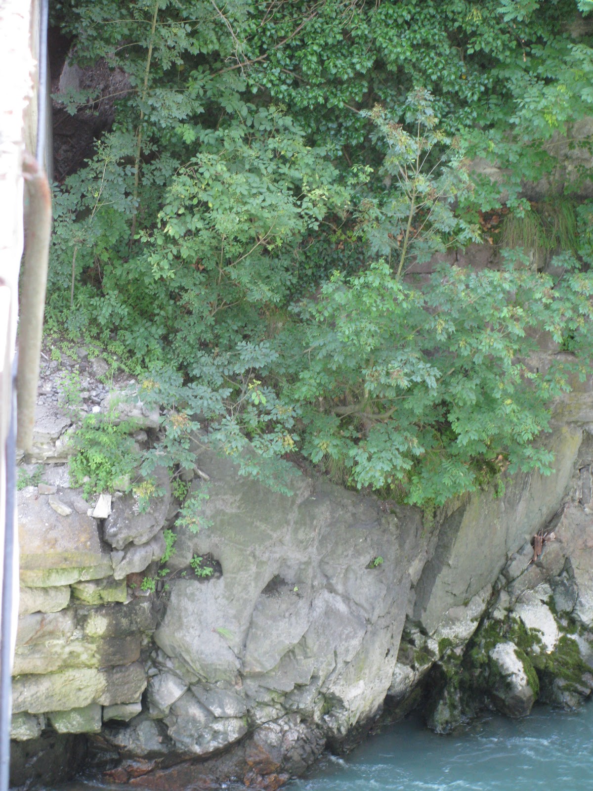
All that remains of the bridge today is a stone abutment, which stands on the left or south bank of the river. This important monument is not signposted in any way, and it is fairly difficult to get a view of. You can lean right out from the parapet of the existing concrete bridge and see at least part of the stonework from above (in the bottom left quarter of this picture, which you can enlarge by clicking):
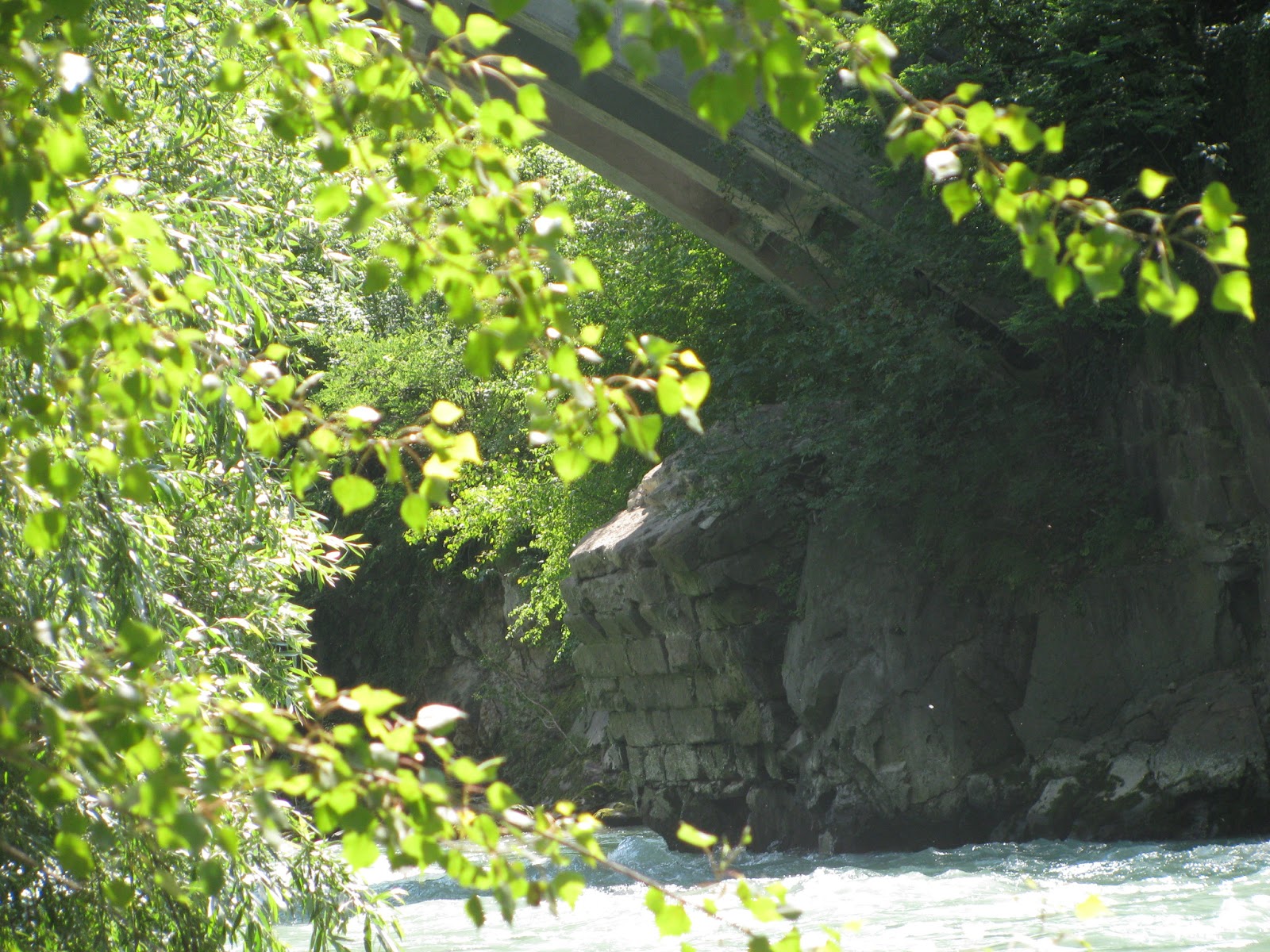
A better view is obtained by driving down an asphalted lane on the right bank, and scrambling over steep loose soil to the water's edge, down-river from the bridge. Here it is possible to stand on a sandbank and peer through fronds of trees, obtaining a view of how the abutment curves up into the beginning of an arch. Eight layers of stone remain. It may be that some of the collapsed bridge is still here in the river-bed.
The next picture shows the structure, with the arch of a 20th-century concrete bridge above it. The remains are in shadow at the centre of the picture. It might have been better to wait all day until the sunlight was not so bright and then take a picture, but my dear wife and son came along for this expedition and we had some other pleasures such as hiking to also accomplish that day, so this picture will have to do:
Probably the most recent professional description of one of Late Antiquity's most neuralgic sites is that by Vittorio Galliazzo, the great scholarly authority on Roman bridges, who examined the structure in 1999. I do not know much Italian, so I have used Bing and Google Translate to essay the following rough translation from pages 64-65 of his 2002 article,
Ponti e Forme di Attraversamento di Corsi d’Acqua dell’Alto Adige in Età Romana. Please let me know if you can improve or correct the translation:
Near a site that has already yielded a milestone from the reign of Maxentius (CIL V 8054 = 463 IBR), the left abutment of an ancient bridge on the old road through the Eisack Valley, together with a section of an arch almost up to its waist, was found in 1930 about 5 kilometres east of Bolzano during reconstruction of a bridge that forms part of the Brenner Highway. Further investigation at the end of 1988 by Dr. Lorenzo Dal Ri of the Archaeological Heritage Office of Bolzano Province confirmed that these remains were probably Roman. An architect, Andrea Perin, subsequently suggested his own reconstruction in a sketch based on the scant reliable information available and a good deal of hypothesis.
From the details that follow, one understands what an engineering challenge the structure posed for its designers and builders: it had to cross high-volume rapids that are susceptible to flash floods. Land access to the cramped site is blocked from north and south. No boats could be used. A huge wooden frame had to be assembled to hold the large number of wedgestones during construction.
No piles could be driven: the footings had to be carved out of solid rock.
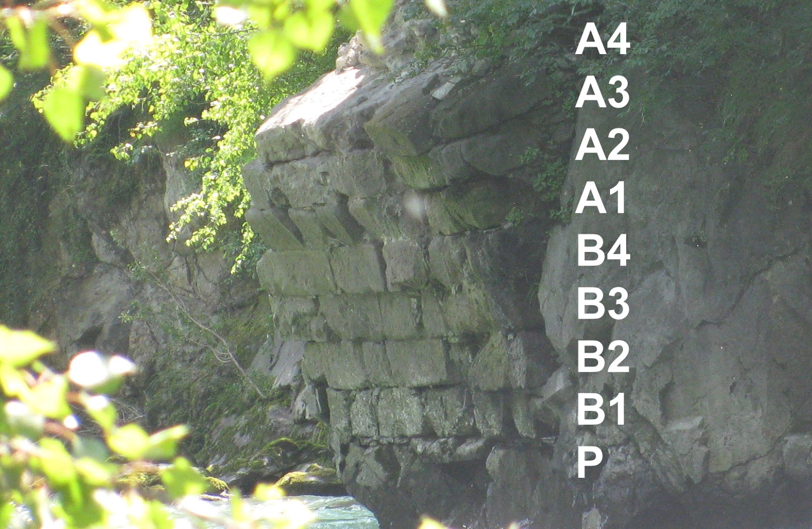
The section that follows is awkward to follow without any picture, so I have inserted letters into Galliazzo's account in square brackets, so that you can see in this detail from my photo which layers he is talking about:

The abutment is approximately 4.50 m wide at its base and consists of four rows of blocks of compact yellowish stone of modest thickness [B1, B2, B3, B4] which protrude on the upstream side, as if to form a protective flank with the aid of the carefully modelled porphyry stone of the riverbank. The abutment is fitted into a cavity specially hollowed out of the dark porphyry rock [P] on the left bank, evened out as need be with sandstone slabs. The sector of arch, which is about 4 metres wide, tops this support structure and likewise consists of yellowish blocks of porphyry. One sees four rows of wedge-stones, three of them [A1, A2, A3] nearly intact and one fragmented [A4].
All the surviving structure of the abutment is in big chiselled blocks, tied with leaded iron clamps. Several stones, especially the upstream ones in the third and fourth row [B3, B4], have rusticated faces with listello or refesso drafted margins. The arch segment appears to have had an intrados in opus vittatum consisting of rather small blocks joined with hard lime.
From what I could see directly during a first inspection in 1994 and a subsequent survey in 1999, the first row from the bottom in the remaining sector of the arch [A1], that is to say counting up from the join, comprised four quadrangular, regularly dimensioned blocks, with a fifth flanking them upstream while a sixth downstream from them was tailored to fit into the “living” rock. This layer was surely used at the time of construction to support a hoop-shaped wooden scaffold and then probably re-used as the footing for the wooden beams of the later medieval bridge, which was no longer a stone arch but probably a wooden truss (i.e. a series of vertical stays supporting a horizontal wooden superstructure). At about 10 and 21 metres respectively from this ancient abutment, you can see the remains of two piers in the bed of the Eisack River on which uprights of the scaffolding for the boxing to construct the 1928-1930 concrete bridge stood before they collapsed.
Galliazo's article includes two black and white photographs evidently taken in winter when there was less vegetation obscuring the view. He also reproduces Perin's sketch although he repudiates its veracity. Galliazzo concludes with the following general assessment of the structure:
It seems that the whole bridge, from abutment to abutment, had a length of about 33-34 metres which could be feasibly crossed not with three arches as has been proposed in the draft reconstruction, but with just two asymmetrical arches. This would result in a bridge similar to that at Merano with arches supported on sturdy abutments built into the rock of the banks and one pier of considerable proportions outside the river current: the greater of the two arches would have been on the left of the river and would have needed to have a length of about 18-20 meters to straddle the channel, while the lesser arch would have had an opening of less than 8 meters and would have probably provided an extra discharge during floods to better withstand the water pressure.
As regards the dating of the structure, the arrangement of the stone blocks and the overall impression given by the remnant of the abutment would suggest engineering of the Imperial if not of the Late Antique period, perhaps replacing an earlier bridge in wood, a material that was very abundant in the region. The collapse of this structure must have occurred by the Middle Ages, since the medieval timber replacement can be dated in all likelihood to the first half of the fourteenth century. It would seem to date from between 1314, when Count Heinrich of Tyrol commissioned the entrepreneur H. Kunter by contract to open an Eisack valley trail, the Kuntersweg, and 1390, when a document includes mention of construction of a bridge at Blumau.
It is notable that Galliazzo rejects the hypothesis that the structure could be the
Pons Drusi which is marked on the
Peutinger Diagram but in no other documentary source. He and other authors of the Südtirol archaeology volume consider the
Pons Drusi to have been a bridge in the heart of Bolzano.
I took only rough notes from his bibliography and have not read these further materials, so I apologize that I must offer these references here with incomplete titles. The 1930 report at page 366 of
Archivio per l'Alto Adige that first pointed to the existence of these remains should also be added to this reading list:
Dal Ri, Lorenzo. “?Title unknown.” In La Venetia nell’area padano-danubiana: le vie di comunicazione: Convegno internazionale: Papers, edited by Guido Rosada. Padova: CEDAM, 1990. See 620-621.
Galliazzo, Vittorio. I ponti romani. Vol. 1. 2 vols. Treviso: Canova, 1995. See 149, 249, 399.
———. “Ponti e Forme di Attraversamento di Corsi d’Acqua dell’Alto Adige in Età Romana.” In Archäologie der Römerzeit in Südtirol. Beiträge und Forschungen. Forschungen zur Denkmalpflege in Südtirol, edited by Lorenzo Dal Ri and S. Di Stefano, 57-71. 1, 2002. [The article quoted in this post.]
———. , ed. Via Claudia Augusta: un’arteria alle origini dell’Europa: ipotesi, problemi, prospettive : atti del Convegno internazionale Feltre 24-25 settembre 1999. Comune di Feltre, 2002. See 233, 236.
Olivi, M. “?Title unknown (‘Strada Romana Bolzano-Ponte Gardena’ or similar).” Archeologia Veneta 7 (1984). See 256-257.
Tabarelli, Gian Maria. Strade Romane nel Trentino e nell’Alto Adige. Trento: Temi Ed., 1994. See 122-125.
Regrettably, this very important structure is not yet included (at the time of this posting) in Wikipedia's
List of Roman Bridges.